
Feed aggregator
Lala Batters Hawaii
- Earth
- Earth Observatory
- Image of the Day
- EO Explorer
- Topics
- More Content
- About
Lala Batters Hawaii
- Earth
- Earth Observatory
- Image of the Day
- EO Explorer
- Topics
- More Content
- About
Mars Curiosity Rover Discovers Massive Field of Polygons
The surface of Mars is home to some of the most breathtaking and awe-inspiring landscapes in the solar system. This is primarily due to the Red Planet lacking several re-surfacing processes that Earth possesses, including plate tectonics, volcanism, and flowing water. While Mars does have dust storms, this has done little to reshape the planet’s surface, which has remained largely undisturbed for billions of years. However, this near-pristine landscape has enabled scientists to look back in time while slowly piecing together what Mars was like long ago.
MOTHRA Shows Us A Star Being Recycled in the Helix Nebula
Astronomers used new MOTHRA telescope in Chile to image the famous Helix Nebula. They found 22 glowing shock waves where stellar debris from a dying star collided with interstellar gas. After colliding with gas, stellar fragments remain intact for just 10,000 years, the team estimates. The observations show how dying stars are recycled and return material to the interstellar medium to form new stars and planets.
Curiosity Blog, Sols 4975-4981: Happy 14th Landing Anniversary
- Curiosity Home
- Science
- News and Features
- Multimedia
- Mars Missions
- Mars Home
6 min read
Curiosity Blog, Sols 4975-4981: Happy 14th Landing Anniversary NASA’s Mars rover Curiosity acquired this image, of its onboard APXS instrument measuring target “Tunas Khasa,” using its Front Hazard Avoidance Camera (Front Hazcam). Curiosity captured the image on Sol 4976 — Martian day 4,976 of the Mars Science Laboratory mission — at 03:01:56 UTC.NASA/JPL-Caltech
By Susanne P. Schwenzer, Professor of Planetary Mineralogy at The Open University, UK
Earth planning date: Friday, Aug. 7, 2026
This week was very special for the Curiosity team here on Earth as we celebrated the 14th landing anniversary. I still remember watching the buildup to the entry phase on “Eyes on the Solar System” and then I don’t remember much until I heard the words, “We are safe on Mars.” I was just too tense and nervous, but I love to re-live the moments each year when we celebrate another (Earth) year on Mars. If you want to remember it all, you can go to NASA’s interactive tool “Eyes on the Solar System” use the menu and find the Mars Science Laboratory Rover in the list of spacecraft. Curiosity launched Nov. 26, 2011, 15:02 UTC; you can wind back the clock to that day as the spacecraft leaves Earth and follow as it gradually makes its way to Martian orbit, where it meets Mars at just the right moment. Curiosity landed Aug. 6, 2012, 05:17 UTC. The big moment to me, though, is to see the joy and celebrations in the control room after landing. I have watched this video more times than I can count; it’s just too good to not remember: Curiosity Has Landed – NASA Science.
But what did we do in that very special week that marked the transition from year 14 to year 15? Of course it was business as usual for the rover while many of us exchanged memories and also marveled at what we have found to date. If you are interested what exactly Curiosity did at the moment in time that marked the landing anniversary, we’ve got you covered — with the help of the science and engineering team at JPL in Pasadena, I can tell you that this was on Sol 4976 at 19:47 LMST on Mars, and at that very moment the rover’s arm was deployed at the target “Tunas Khasa” doing an APXS measurement.
The rover continued its way up Mount Sharp investigating the different layers of rock along the way. This climb can be quite steep and coming into Monday’s plan was no different. At one point last Friday the rover’s tilt was 24 degrees. But the engineers know exactly what Curiosity can do, so we arrived safely at our planned location coming into Monday. At this first stop of the week, the APXS measured “Tunas Khasa” and “Villarrica,” which were also imaged with our Mars Hand Lens Imager (MAHLI). More chemistry came from ChemCam investigating the targets “Lago Rupanco” and “Chulipa Punta.” ChemCam also used its Remote Micro Imager to acquire high-resolution images of targets of interest. We are specifically looking for the cross-bedding, a term geologists use to describe rock layers that tilt and intersect each other, and how the different layers of rock relate to each other. Mastcam had five different mosaics in the plan, investigating targets in the nearfield and looking into the distance, too. The targets range from layers of rocks in the walls that make up the buttes around the rover to bedrock targets in the nearfield. “La Linea” is a surface that displays signs of erosion, and “Tiraque” gives insights into the layering of the bedrock, just to name two of the Mastcam targets. Of course, the future drive direction and the future workspace were also imaged after the drive. In addition to the science, there were some “housekeeping” activities in the plan, too. Those were a SAM column-cleaning activity and MAHLI images of the REM UV sensor. It’s important to keep on top of these things, too!
The 46-foot (14-meter) drive put us into the perfect position in front of one of those very special places, where not only two different rock layers meet, but also where cross-bedded rocks are truncated by other layers. It is those special places that allow us – one by one – to put the pieces of the puzzle together, showing what happened here billions of years ago. One thing is clear: it involved wind, lots of wind, but also some water. As this location is an exceptionally interesting place, we will stay here through Monday and spend two planning cycles at this location.
On Friday we planned two APXS on a bedrock block in front of us – keeping in mind two others for our colleagues to plan on Monday. The two targets are “Salar de Gorbea” and “Uriondo.” MAHLI documents those two, but also has a mosaic in the plan that is one of the largest I have ever seen. It’s on the target “Tres Morros,” which is an excellent example on how exactly those different rock layers meet. The team can’t wait to see the high-resolution MAHLI images and inspect every single detail visible in them. Mastcam also was very busy, investigating representative outcrops in the nearfield and further away. Targets to especially look out for are “Laguna Del Eulogio” and “Laguna de Pozuelo,” as they image outcrops related to the changes in the rock layers and further ahead on a butte called Mishe Mokwa. You might remember the latter from many mentions previously as we were driving along and around it, and using repeated images to get stereo views, but also understand different aspects of the stratigraphy (the way rocks are layered). ChemCam looks at target “Rio Tranquilo,” which is a nodular target, possibly giving insights into the water-related part of the environments that formed those rocks. The other ChemCam target is “Rio Juncalito,” which is a cross-bedded target. ChemCam also has two RMIs in the plan, one targeting forward toward Valle Grande and the other looking at Mishe Mokwa.
Both plans contain a rich set of environmental monitoring. There are many dust-devil surveys alongside measurements of the atmospheric opacity and wind monitoring. We are also looking for clouds, and of course the RAD instrument is actively measuring the radiation environment. It rarely gets a mention here, because it sits quietly in its place within the rover, looking out to the sky and monitoring the radiation — for all those 14 years, and in fact a little longer, because it was the first instrument to be switched on after launch and already started its monitoring during the cruise phase to Mars.
Happy 14th Landing Anniversary, Curiosity!
-
Want to read more posts from the Curiosity team?
-
Want to learn more about Curiosity’s science instruments?
Mars is the fourth planet from the Sun, and the seventh largest. It’s the only planet we know of inhabited…
All Mars ResourcesExplore this collection of Mars images, videos, resources, PDFs, and toolkits. Discover valuable content designed to inform, educate, and inspire,…
Rover BasicsEach robotic explorer sent to the Red Planet has its own unique capabilities driven by science. Many attributes of a…
Mars Exploration: Science GoalsThe key to understanding the past, present or future potential for life on Mars can be found in NASA’s four…
Curiosity Blog, Sols 4975-4981: Happy 14th Landing Anniversary
- Curiosity Home
- Science
- News and Features
- Multimedia
- Mars Missions
- Mars Home
6 min read
Curiosity Blog, Sols 4975-4981: Happy 14th Landing Anniversary NASA’s Mars rover Curiosity acquired this image, of its onboard APXS instrument measuring target “Tunas Khasa,” using its Front Hazard Avoidance Camera (Front Hazcam). Curiosity captured the image on Sol 4976 — Martian day 4,976 of the Mars Science Laboratory mission — at 03:01:56 UTC.NASA/JPL-CaltechBy Susanne P. Schwenzer, Professor of Planetary Mineralogy at The Open University, UK
Earth planning date: Friday, Aug. 7, 2026
This week was very special for the Curiosity team here on Earth as we celebrated the 14th landing anniversary. I still remember watching the buildup to the entry phase on “Eyes on the Solar System” and then I don’t remember much until I heard the words, “We are safe on Mars.” I was just too tense and nervous, but I love to re-live the moments each year when we celebrate another (Earth) year on Mars. If you want to remember it all, you can go to NASA’s interactive tool “Eyes on the Solar System” use the menu and find the Mars Science Laboratory Rover in the list of spacecraft. Curiosity launched Nov. 26, 2011, 15:02 UTC; you can wind back the clock to that day as the spacecraft leaves Earth and follow as it gradually makes its way to Martian orbit, where it meets Mars at just the right moment. Curiosity landed Aug. 6, 2012, 05:17 UTC. The big moment to me, though, is to see the joy and celebrations in the control room after landing. I have watched this video more times than I can count; it’s just too good to not remember: Curiosity Has Landed – NASA Science.
But what did we do in that very special week that marked the transition from year 14 to year 15? Of course it was business as usual for the rover while many of us exchanged memories and also marveled at what we have found to date. If you are interested what exactly Curiosity did at the moment in time that marked the landing anniversary, we’ve got you covered — with the help of the science and engineering team at JPL in Pasadena, I can tell you that this was on Sol 4976 at 19:47 LMST on Mars, and at that very moment the rover’s arm was deployed at the target “Tunas Khasa” doing an APXS measurement.
The rover continued its way up Mount Sharp investigating the different layers of rock along the way. This climb can be quite steep and coming into Monday’s plan was no different. At one point last Friday the rover’s tilt was 24 degrees. But the engineers know exactly what Curiosity can do, so we arrived safely at our planned location coming into Monday. At this first stop of the week, the APXS measured “Tunas Khasa” and “Villarrica,” which were also imaged with our Mars Hand Lens Imager (MAHLI). More chemistry came from ChemCam investigating the targets “Lago Rupanco” and “Chulipa Punta.” ChemCam also used its Remote Micro Imager to acquire high-resolution images of targets of interest. We are specifically looking for the cross-bedding, a term geologists use to describe rock layers that tilt and intersect each other, and how the different layers of rock relate to each other. Mastcam had five different mosaics in the plan, investigating targets in the nearfield and looking into the distance, too. The targets range from layers of rocks in the walls that make up the buttes around the rover to bedrock targets in the nearfield. “La Linea” is a surface that displays signs of erosion, and “Tiraque” gives insights into the layering of the bedrock, just to name two of the Mastcam targets. Of course, the future drive direction and the future workspace were also imaged after the drive. In addition to the science, there were some “housekeeping” activities in the plan, too. Those were a SAM column-cleaning activity and MAHLI images of the REM UV sensor. It’s important to keep on top of these things, too!
The 46-foot (14-meter) drive put us into the perfect position in front of one of those very special places, where not only two different rock layers meet, but also where cross-bedded rocks are truncated by other layers. It is those special places that allow us – one by one – to put the pieces of the puzzle together, showing what happened here billions of years ago. One thing is clear: it involved wind, lots of wind, but also some water. As this location is an exceptionally interesting place, we will stay here through Monday and spend two planning cycles at this location.
On Friday we planned two APXS on a bedrock block in front of us – keeping in mind two others for our colleagues to plan on Monday. The two targets are “Salar de Gorbea” and “Uriondo.” MAHLI documents those two, but also has a mosaic in the plan that is one of the largest I have ever seen. It’s on the target “Tres Morros,” which is an excellent example on how exactly those different rock layers meet. The team can’t wait to see the high-resolution MAHLI images and inspect every single detail visible in them. Mastcam also was very busy, investigating representative outcrops in the nearfield and further away. Targets to especially look out for are “Laguna Del Eulogio” and “Laguna de Pozuelo,” as they image outcrops related to the changes in the rock layers and further ahead on a butte called Mishe Mokwa. You might remember the latter from many mentions previously as we were driving along and around it, and using repeated images to get stereo views, but also understand different aspects of the stratigraphy (the way rocks are layered). ChemCam looks at target “Rio Tranquilo,” which is a nodular target, possibly giving insights into the water-related part of the environments that formed those rocks. The other ChemCam target is “Rio Juncalito,” which is a cross-bedded target. ChemCam also has two RMIs in the plan, one targeting forward toward Valle Grande and the other looking at Mishe Mokwa.
Both plans contain a rich set of environmental monitoring. There are many dust-devil surveys alongside measurements of the atmospheric opacity and wind monitoring. We are also looking for clouds, and of course the RAD instrument is actively measuring the radiation environment. It rarely gets a mention here, because it sits quietly in its place within the rover, looking out to the sky and monitoring the radiation — for all those 14 years, and in fact a little longer, because it was the first instrument to be switched on after launch and already started its monitoring during the cruise phase to Mars.
Happy 14th Landing Anniversary, Curiosity!
-
Want to read more posts from the Curiosity team?
-
Want to learn more about Curiosity’s science instruments?
Mars is the fourth planet from the Sun, and the seventh largest. It’s the only planet we know of inhabited…
All Mars ResourcesExplore this collection of Mars images, videos, resources, PDFs, and toolkits. Discover valuable content designed to inform, educate, and inspire,…
Rover BasicsEach robotic explorer sent to the Red Planet has its own unique capabilities driven by science. Many attributes of a…
Mars Exploration: Science GoalsThe key to understanding the past, present or future potential for life on Mars can be found in NASA’s four…
Webb Captures Clearest Image Yet of the Lion Nebula
The NASA/ESA/CSA James Webb Space Telescope has captured images of NGC 2392 (also known as the Lion Nebula), which Hubble previously imaged in 2000.
Massive Exoplanets Could Form Around Supermassive Black Holes
Black holes aren't just engines of inexorable destruction. They're complex regions of space and time, and under the right conditions, giant planets can form in their AGN disks.
NASA's SkyFall Mars Helicopters Will Feature a Revolutionary Antenna Design
Engineers developed a unique fabric-based design for a ground-penetrating radar that will be a key instrument on NASA’s SkyFall Mars helicopters. The hardware will enable the SkyFall mission’s trio of planetary rotorcraft to use ground-penetrating radar to study the Martian subsurface.
How an ancient collision with another galaxy transformed the Milky Way
The Hubble Space Telescope has discovered evidence that our galaxy experienced a significant collision and merger with a dwarf galaxy 11.8 billion years ago.
Mergers between galaxies are one of the main ways in which galaxies can grow. However, while we can witness mergers taking place in other galaxies, figuring out our Milky Way galaxy's history requires painstaking detective work. Even now, the story is only partly known.
"Our home is the Milky Way galaxy, but we do not know how our house was built," Davide Massari of the Astrophysics and Space Science Observatory of Bologna in Italy said in a statement. Massari is lead author of a paper describing the discovery of an ancient galactic merger. "In this paper we discover where the first significant batch of bricks came from: a dwarf galaxy that we call LKH."
LKH stands for Low-energy–Kraken–Heracles, which is an obtuse reference to three earlier research papers that tangled with the idea of mergers early in our galaxy's history.
In recent years, one other significant merger has come to light, which is a collision with a galaxy referred to as the Gaia–Sausage–Enceladus (GSE) galaxy about 10 billion years ago. The GSE had its own family of globular star clusters that became integrated with the Milky Way's own globular clusters during the collision.
Now, Massari's team have discovered a third population of globular clusters that do not seem to be native to the Milky Way, nor to have belonged to the GSE galaxy. Instead, they seem to have arrived 11.8 billion years ago, which is before the GSE merger.
"Thanks to the high resolution and depth of Hubble imaging, we could measure the age and the metal content of these clusters with unprecedented precision," said astronomer Chiara Zerbinati of the University of Bologna, who is a co-author on the paper. Metals are astronomer-speak for elements heavier than the hydrogen and helium that formed in the Big Bang, so they include the likes of oxygen and carbon as well as iron and aluminum.
"Coupled with measurements from [the European Space Agency mission] Gaia, this made it possible to distinguish a population of globular clusters that are different from the others," said Zerbinati. "These are the clusters that were born in LKH and they tell us when that galaxy was devoured by ours, and how massive it was."
Based on the number and mass of imported globular clusters, the team calculated that LKH had a total mass of 500 million times the mass of our sun. This is only slightly more massive than the Sagittarius Dwarf galaxy (approximately 400 million solar masses), which the Milky Way is currently cannibalizing and an order of magnitude less massive than the Small Magellanic Cloud. However, 11.8 billion years ago, which is just two billion years after the Big Bang, our Milky Way galaxy was much smaller and LKH would have contributed a sizable chunk of mass, in terms of stars, gas and dark matter, to the Milky Way.
The discovery of the merger adds an important new event to the Milky Way's history, one that would have undoubtedly influenced the evolution of our galaxy. For example, the collision could have spurred a fresh burst of star formation, helping the Milky Way to grow, while the chemistry of the stars from LKH will have impacted the Milky Way's overall chemical evolution as those stars died and passed their remains into the interstellar medium to be reborn in new stars.
"Some past studies have argued that the earliest phases of our galaxy's evolution were defined by stars born only in our galaxy," said Massari. "Here, we have shown that stars born in external galaxies also need to be considered."
The discovery of the merger with LKH was reported on Aug. 17 in the journal Nature Astronomy.
NASA Selects Companies to Provide Payload Processing Services

NASA has selected four companies to provide payload processing facilities under the Spacecraft Processing Operations Contract on‑ramp provision. The provision enables qualified providers to offer commercial payload processing services for agency missions launching from multiple locations where capabilities were not available at the time of the initial contract award.
Contract awardees are:
- All Points Logistics LLC
- Blue Origin LLC
- Firefly Aerospace
- L3Harris Technologies Inc.
Through the contract, NASA procures facilities and services required to perform prelaunch processing of spacecraft and associated rocket hardware for delivery to the launch pad.
The Spacecraft Processing Operations Contract is a multiple-award, commercial, firm-fixed-price, indefinite-delivery/indefinite-quantity contract vehicle that has an aggregate ceiling price of $100 million with an ordering period through Feb. 1, 2033.
NASA’s Launch Services Program at the agency’s Kennedy Space Center in Florida will manage the contract. The program works with private industry, mission, and international partners to launch science payloads ranging from small satellites with colleges and universities to NASA’s highest-priority missions.
For more information about NASA’s launch services, visit:
-end-
Joshua Finch
Headquarters, Washington
202-358-2546
joshua.a.finch@nasa.gov
Leejay Lockhart
Kennedy Space Center, Fla.
321-747-8310
leejay.lockhart@nasa.gov
NASA Selects Companies to Provide Payload Processing Services
NASA has selected four companies to provide payload processing facilities under the Spacecraft Processing Operations Contract on‑ramp provision. The provision enables qualified providers to offer commercial payload processing services for agency missions launching from multiple locations where capabilities were not available at the time of the initial contract award.
Contract awardees are:
- All Points Logistics LLC
- Blue Origin LLC
- Firefly Aerospace
- L3Harris Technologies Inc.
Through the contract, NASA procures facilities and services required to perform prelaunch processing of spacecraft and associated rocket hardware for delivery to the launch pad.
The Spacecraft Processing Operations Contract is a multiple-award, commercial, firm-fixed-price, indefinite-delivery/indefinite-quantity contract vehicle that has an aggregate ceiling price of $100 million with an ordering period through Feb. 1, 2033.
NASA’s Launch Services Program at the agency’s Kennedy Space Center in Florida will manage the contract. The program works with private industry, mission, and international partners to launch science payloads ranging from small satellites with colleges and universities to NASA’s highest-priority missions.
For more information about NASA’s launch services, visit:
-end-
Joshua Finch
Headquarters, Washington
202-358-2546
joshua.a.finch@nasa.gov
Leejay Lockhart
Kennedy Space Center, Fla.
321-747-8310
leejay.lockhart@nasa.gov
China bounces back from Long March rocket explosion with back-to-back launches (video)
China just completed not one but two space missions, less than a week after a Long March 7A rocket explosion briefly grounded its fleet.
The state-owned China Aerospace Science and Technology Corporation (CASC) returned to flight with the launch of a Long March 12 rocket from the Hainan Commercial Space Launch Site in Wenchang. The rocket lifted off on Aug. 16 at 12:10 a.m. EDT (0410 GMT; 12:10 p.m. local time in China) and delivered a stack of 24 internet-beaming satellites into low Earth orbit (LEO).
It was the first launch since China's Long March 7A exploded mid-flight on Aug. 10. Footage of that mission showed the Long March 7A's fairing section and the upper portion of the launch vehicle bending backward about 85 seconds after liftoff, resulting in the total loss of the rocket and its payload, the Zhongxing-4B communications satellite.
China's Long March 12 rocket lifted off with a stack of 24 internet satellites on Aug. 16, 2024. (Image credit: CASC/Hu Zhipeng)Less than 24 hours after the successful Long March 12 mission, and about 1,300 miles (2,100 kilometers) north of the Wenchang launch site, a Long March 2C rocket lifted off from the Taiyuan Satellite Launch Center, in Shanxi province. The launch occurred on Aug. 16 at 11:02 p.m. EDT (0302 GMT and 11:02 a.m. local time in China on Aug. 17), and delivered the "SEO" satellite for the United Arab Emirates to its planned orbit, according to the China National Space Administration.
Of the pair launched over the weekend, the Long March 12 is much more similar to the Long March 7A; the two stand 203 feet (62 meters) and 197 feet (60 m) tall, respectively. But the two rockets are designed with different purposes. The slightly wider Long March 12 is a two-stage rocket optimized for delivering relatively heavy payloads to LEO and sun-synchronous orbits, while the three-stage Long March 7A is designed for higher-altitude missions to geostationary transfer orbit and beyond.
In contrast, the Long March 2C stands only about 141 feet (43 m) tall. The two-stage rocket is used primarily for smaller payloads to LEO, with a lifting capacity of only about 3.9 tons, and has a long list of launches dating back to 1982. The newest of the three, the Long March 12, was introduced in 2024 and has now launched seven missions — all successful. Last week was the Long March 7A's second failure in a total of 18 launches since the rocket's debut in 2020.
CASC hasn't provided an update on the Long March 7A incident, other than a statement indicating that the cause is under investigation. As that continues, China has more launches on the horizon.
The second flight of the Zhuque-3 rocket, a launch vehicle designed for reusability from Chinese company Landspace, is scheduled to launch Tuesday evening (Aug. 18), and a Long March 5 rocket carrying the Chang'e 7 robotic mission to the moon's South Pole is expected to lift off on Sunday (Aug. 23).
The best Ruko drone to date is half-price at Amazon but you'll have to hurry
We've seen drone deals come and go, but this Ruko F11 Pro 2 really is something else. Equipped with a 6K camera and built to last, this drone is 54% off at Amazon, saving you $280!
Save $280 on this Ruko F11 Pro 2 drone at Amazon.
In our Ruko F11 Pro 2 review we called it "The best designed and built Ruko drone to date," and that still stands. It can capture 30FPS 4K video, or snap 6K stills and comes with 2 batteries for a 70-minute flight time.
$280 off is a serious saving, though there is one catch. Sold by Ruko and shipped by Amazon, this deal is only available for a day and the clock's already ticking, so you'll have to move fast.
Looking for a different flyer? We've rounded up the best drones and the best beginner drones.
F11 PRO 2: was $520 now $240
Save a massive $280 and get a sturdily-built drone equipped with a 4K video camera and a 6K still camera. With two batteries included, you can fly and photograph for well over an hour. View Deal
- We're constantly checking the best prices on our pages for big discounts on the best telescopes, binoculars, star projectors, cameras, drones, Lego, streaming and more.
This Ruko F11 PRO 2 drone bundle has everything you need to take to the air, including two batteries which offer over an hour of flight time. It's easy to use and its stability is bolstered by its three-gimbal system.
It offers video capture in in 4K at 30 FPS, 2.7K at 30/50 FPS and 2K at 50 FPS, and 6K image capture. Flight modes include subject tracking modes, GPS positioning and Return to Home (RTH). While it doesn't sport collision avoidance, it's well-built enough that it should withstand a few minor bumps and scrapes.
It is worth bearing in mind that as it weighs above 250g, drone regulations say you'll have to register it with the FAA. So if you're gifting this to a beginner, be sure to remind them.
At less than half price, the Ruko F11 PRO 2 is an absolute steal for just $240. But you'll have to hurry because this is a limited-time offer.
Key features: 12.6 oz / 357 g weight, up to 70 minutes flight per battery, USB-C charger, 4K, 2.7K, 2K, 720p video resolutions, up to 30FPS at 4K, 6K still images.
Product launched: November 2024
Price history: The lowest this drone has been is $290, it tends to stay in the region of $350-400.
Price comparison: Amazon: $240 | Walmart: $300
Space: ★★★
Review consensus: This is a well-built, easy-to-fly drone, though its camera could offer more in the way of options.
✅ Buy it if: You want a beginner-friendly drone that offers extended flight time and excellent flight stability.
❌ Don't buy it if: You want to fine control over your images; the camera is fully automatic. Instead, consider one of the best camera drones.
Check out our other guides to the best telescopes, binoculars, cameras, star projectors, drones, lego and much more.
OpenAI funds research to try to stop AI from being used to make bioweapons
The start-up’s grant to the Nuclear Threat Initiative will fund an international information sharing system designed to flag biosecurity threats from AI
The JWST Little Red Dots Could Be 'Black Hole Stars'
Little red dots have puzzled astronomers since their discovery in JWST data from the Universe’s deep past. Their ‘powering engines’ might resemble a newly discovered phenomenon dubbed a “black hole star”—an early, rapidly growing black hole wrapped in dense gas. This object, described in a study published today in Nature by researchers at the Institute of Science and Technology Austria (ISTA) and international collaborators, may help explain how billion-solar-mass black holes formed so soon after the Big Bang.
NASA Mission Studies Air Pollution Over Ethiopia
5 min read
Preparations for Next Moonwalk Simulations Underway (and Underwater) A busy street in Addis Ababa, Ethiopia’s capital, which is the subject of NASA-led air quality research.Ninaras (CC BY-SA 4.0)
A NASA-funded air pollution monitoring network has provided one of the most detailed long-term views yet of the role of black carbon, or soot produced by fires, diesel vehicles, and other combustion sources, in Ethiopia’s capital, Addis Ababa. The detailed measurements show how pollution changes by time of day and season, including increases associated with rush-hour traffic and holiday celebrations. The findings are relevant to cities around the world, including in the United States.
In a new paper published in ES&T: Air, scientists analyzed data collected throughout Addis Ababa between 2022 and 2025 from 10 air-quality monitoring sites deployed by NASA’s Multi-Angle Imager for Aerosols (MAIA) project.
The research comes as Ethiopia is taking steps aimed at improving air quality. In 2024, the country became the first in the world to ban the import of internal combustion engine vehicles, while cities have been adding bike lanes and electric vehicle infrastructure. The MAIA project’s measurements provide researchers with a baseline for understanding how air quality changes over time as Addis Ababa continues to grow and evolve.
The study focuses on particulate matter that is 2.5 micrometers or less in diameter, also known as PM2.5. The 2025 State of Global Air Report, cited in the paper, estimates that exposure to PM2.5 is associated with approximately 4.9 million deaths globally each year. Among the many kinds of PM2.5, black carbon has been has been studied for its potential effects on human health.
The paper found that Addis Ababa’s three-year average PM2.5 concentration was 30 micrograms per cubic meter, which is more than three times the level of the U.S. Environmental Protection Agency’s health-based annual PM2.5 standard. The new paper cites data from MAIA’s ground sensors indicating that average black carbon levels in Addis Ababa were approximately four to nine times higher than those measured in the three U.S. metropolitan areas the mission is monitoring.
This roof-mounted air sensor in Addis Ababa, the capital of Ethiopia, is one of 10 used by NASA’s MAIA mission to study the city’s air quality. MAIA’s air sensors provide a detailed look at PM2.5, one of the world’s deadliest forms of air pollution. NASA/JPL-Caltech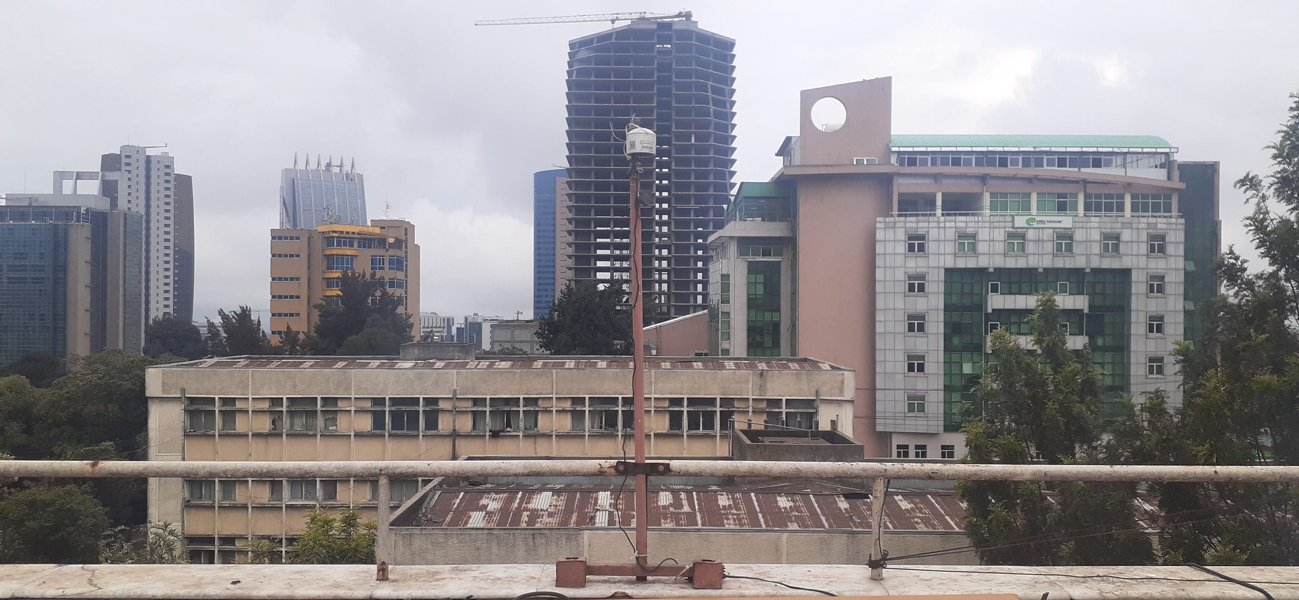
“To our knowledge, this is the first long-term, multisite study of continuous PM2.5 and black carbon measurements in Ethiopia,” said Sina Hasheminassab, a coauthor of the paper and MAIA’s deputy principal investigator at NASA’s Jet Propulsion Laboratory in Southern California. “Many rapidly growing cities have limited long-term monitoring, so these measurements provide an important baseline for understanding how pollution changes across space and time.”
The composition and sources of PM2.5 can differ substantially between cities, depending on their local geography, traffic, industries, and more. Desert cities, for example, may have more dust, while those near coal-fired power plants may have higher concentrations of sulfate. Long-term surface measurements remain limited in many parts of the world.
NASA is supporting MAIA’s air pollution research in a dozen metropolitan areas around the globe, including three in the U.S.: Los Angeles, Atlanta, and Boston. The mission consists of a ground-based network of sensors already in operation as well as a space observatory, which uses a JPL-built camera that will be launched by the Italian Space Agency (ASI) on an ASI satellite no earlier than late 2027.
The camera is designed to identify different types of PM2.5 aerosols based on how they reflect light, making it possible to map particle concentrations over each city that the mission studies. Mounted on a gimbal, the camera captures data from multiple angles using JPL-pioneered technologies that make particles stand out more prominently against the surface background to provide valuable information about their shape and size.
The MAIA mission is the first NASA project to include public health researchers among a space mission’s team. These researchers will use MAIA’s PM2.5 concentration maps alongside health data to study potential relationships between different particle types and health outcomes. By developing a better understanding of particulate matter pollution, researchers can potentially advance how air quality is studied and managed.
“This paper shows how valuable the air sensor data is on its own, but combining the sensor network and satellite observations will be a game-changer,” said, Kyan Shlipak, the paper’s lead author, who worked on the research while interning at JPL.
Tracking black carbon
The greater Addis Ababa urban area is home to nearly 6 million people, and according to United Nations projections, that figure is expected to surpass 10 million by 2050.
This map of Addis Ababa, the capital of Ethiopia, shows the locations of 10 air sensors that NASA’s MAIA mission is using to provide one of the most detailed looks ever at the city’s air pollution. NASA/JPL-Caltech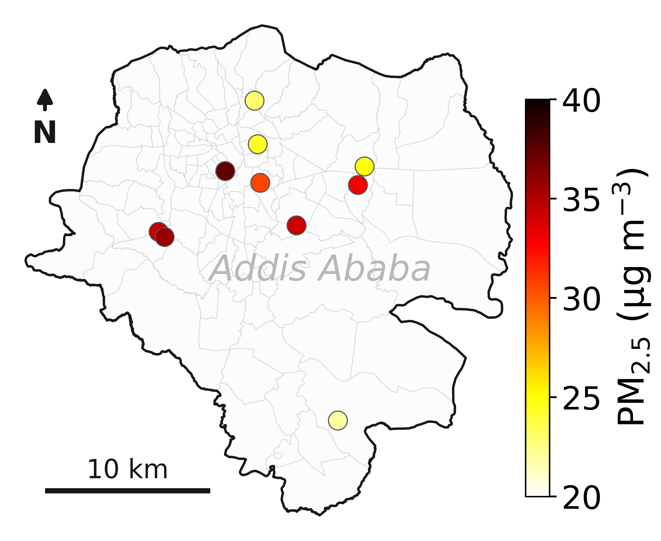
“It’s a cosmopolitan city with many international communities,” said Araya Asfaw of Addis Ababa University, a coauthor of the paper and the MAIA project’s lead Ethiopian collaborator. “Think of it as Africa’s version of Brussels, where the European Union is based.”
“Even at night, when traffic dies down, you see high emissions from the burning of charcoal and other fuels,” Asfaw said.
The MAIA sensor network detected increases in black carbon during two major holidays in Addis Ababa that involve bonfires and was able to distinguish between particles originating from the fires and those from fossil fuel combustion. The findings demonstrate how detailed measurements can help researchers identify different sources of particulate matter and better understand how air quality varies across a city and over time.
To learn more about MAIA, visit:
https://science.nasa.gov/mission/maia/
2026-056
Share Details Last Updated Aug 17, 2026 Related Terms Explore More 3 min read Lala Batters HawaiiThe powerful storm delivered extreme rainfall and damaging winds to the state, passing the Island…
Article 20 hours ago 3 min read Next Generation of Planetary Scientists Learn Public Engagement SkillsFORCE is a world-class laboratory that uses high-pressure experimental equipment to recreate the extreme conditions…
Article 1 day ago 6 min read Chasing Fire Clouds in UtahNASA aircraft are sampling smoke lofted high into the atmosphere by one of the most…
Article 2 days ago Keep Exploring Discover Related Topics Explore Earth ScienceFrom its origins, NASA has studied our planet in novel ways, using a fleet of satellites and ambitious airborne and ground-based…
MAIAMAIA (Multi-Angle Imager for Aerosols) will study the size, makeup, and quantity of airborne particles, to show how this pollution…
Earth Science DataOpen access to NASA’s archive of Earth science data
Earth Science MissionsIn order to study the Earth as a whole system and understand how it is changing, NASA develops and supports…
Keep Exploring Discover More Topics From NASANASA Opens Registration for 2015 Exploration Rover Challenge
OIIR Nav
NASA Mission Studies Air Pollution Over Ethiopia
5 min read
Preparations for Next Moonwalk Simulations Underway (and Underwater) A busy street in Addis Ababa, Ethiopia’s capital, which is the subject of NASA-led air quality research.Ninaras (CC BY-SA 4.0)A NASA-funded air pollution monitoring network has provided one of the most detailed long-term views yet of the role of black carbon, or soot produced by fires, diesel vehicles, and other combustion sources, in Ethiopia’s capital, Addis Ababa. The detailed measurements show how pollution changes by time of day and season, including increases associated with rush-hour traffic and holiday celebrations. The findings are relevant to cities around the world, including in the United States.
In a new paper published in ES&T: Air, scientists analyzed data collected throughout Addis Ababa between 2022 and 2025 from 10 air-quality monitoring sites deployed by NASA’s Multi-Angle Imager for Aerosols (MAIA) project.
The research comes as Ethiopia is taking steps aimed at improving air quality. In 2024, the country became the first in the world to ban the import of internal combustion engine vehicles, while cities have been adding bike lanes and electric vehicle infrastructure. The MAIA project’s measurements provide researchers with a baseline for understanding how air quality changes over time as Addis Ababa continues to grow and evolve.
The study focuses on particulate matter that is 2.5 micrometers or less in diameter, also known as PM2.5. The 2025 State of Global Air Report, cited in the paper, estimates that exposure to PM2.5 is associated with approximately 4.9 million deaths globally each year. Among the many kinds of PM2.5, black carbon has been has been studied for its potential effects on human health.
The paper found that Addis Ababa’s three-year average PM2.5 concentration was 30 micrograms per cubic meter, which is more than three times the level of the U.S. Environmental Protection Agency’s health-based annual PM2.5 standard. The new paper cites data from MAIA’s ground sensors indicating that average black carbon levels in Addis Ababa were approximately four to nine times higher than those measured in the three U.S. metropolitan areas the mission is monitoring.
This roof-mounted air sensor in Addis Ababa, the capital of Ethiopia, is one of 10 used by NASA’s MAIA mission to study the city’s air quality. MAIA’s air sensors provide a detailed look at PM2.5, one of the world’s deadliest forms of air pollution. NASA/JPL-Caltech“To our knowledge, this is the first long-term, multisite study of continuous PM2.5 and black carbon measurements in Ethiopia,” said Sina Hasheminassab, a coauthor of the paper and MAIA’s deputy principal investigator at NASA’s Jet Propulsion Laboratory in Southern California. “Many rapidly growing cities have limited long-term monitoring, so these measurements provide an important baseline for understanding how pollution changes across space and time.”
The composition and sources of PM2.5 can differ substantially between cities, depending on their local geography, traffic, industries, and more. Desert cities, for example, may have more dust, while those near coal-fired power plants may have higher concentrations of sulfate. Long-term surface measurements remain limited in many parts of the world.
NASA is supporting MAIA’s air pollution research in a dozen metropolitan areas around the globe, including three in the U.S.: Los Angeles, Atlanta, and Boston. The mission consists of a ground-based network of sensors already in operation as well as a space observatory, which uses a JPL-built camera that will be launched by the Italian Space Agency (ASI) on an ASI satellite no earlier than late 2027.
The camera is designed to identify different types of PM2.5 aerosols based on how they reflect light, making it possible to map particle concentrations over each city that the mission studies. Mounted on a gimbal, the camera captures data from multiple angles using JPL-pioneered technologies that make particles stand out more prominently against the surface background to provide valuable information about their shape and size.
The MAIA mission is the first NASA project to include public health researchers among a space mission’s team. These researchers will use MAIA’s PM2.5 concentration maps alongside health data to study potential relationships between different particle types and health outcomes. By developing a better understanding of particulate matter pollution, researchers can potentially advance how air quality is studied and managed.
“This paper shows how valuable the air sensor data is on its own, but combining the sensor network and satellite observations will be a game-changer,” said, Kyan Shlipak, the paper’s lead author, who worked on the research while interning at JPL.
Tracking black carbon
The greater Addis Ababa urban area is home to nearly 6 million people, and according to United Nations projections, that figure is expected to surpass 10 million by 2050.
This map of Addis Ababa, the capital of Ethiopia, shows the locations of 10 air sensors that NASA’s MAIA mission is using to provide one of the most detailed looks ever at the city’s air pollution. NASA/JPL-Caltech“It’s a cosmopolitan city with many international communities,” said Araya Asfaw of Addis Ababa University, a coauthor of the paper and the MAIA project’s lead Ethiopian collaborator. “Think of it as Africa’s version of Brussels, where the European Union is based.”
“Even at night, when traffic dies down, you see high emissions from the burning of charcoal and other fuels,” Asfaw said.
The MAIA sensor network detected increases in black carbon during two major holidays in Addis Ababa that involve bonfires and was able to distinguish between particles originating from the fires and those from fossil fuel combustion. The findings demonstrate how detailed measurements can help researchers identify different sources of particulate matter and better understand how air quality varies across a city and over time.
To learn more about MAIA, visit:
https://science.nasa.gov/mission/maia/
2026-056
Share Details Last Updated Aug 17, 2026 Related Terms Explore More 3 min read Next Generation of Planetary Scientists Learn Public Engagement SkillsFORCE is a world-class laboratory that uses high-pressure experimental equipment to recreate the extreme conditions…
Article 9 hours ago 6 min read Chasing Fire Clouds in UtahNASA aircraft are sampling smoke lofted high into the atmosphere by one of the most…
Article 23 hours ago 2 min read Volunteer Develops Machine-Learning Tool to Identify Rare CloudsCertain kinds of clouds are misbehaving – appearing more often and lower in the sky…
Article 3 days ago Keep Exploring Discover Related Topics Explore Earth ScienceFrom its origins, NASA has studied our planet in novel ways, using a fleet of satellites and ambitious airborne and ground-based…
MAIAMAIA (Multi-Angle Imager for Aerosols) will study the size, makeup, and quantity of airborne particles, to show how this pollution…
Earth Science DataOpen access to NASA’s archive of Earth science data
Earth Science MissionsIn order to study the Earth as a whole system and understand how it is changing, NASA develops and supports…
Keep Exploring Discover More Topics From NASANASA Opens Registration for 2015 Exploration Rover Challenge
OIIR Nav