
Feed aggregator
The secrets to keeping your brain sharp in old age
NASA Uses Machine Learning to Enhance Flash Flood Warnings
Close
To view this video please enable JavaScript, and consider upgrading to a web browser that
supports HTML5 video
Created with support from NASA’s Earth Science Technology Office (ESTO), TACLS leverages machine learning to automatically locate evidence (unusual increases in atmospheric moisture) of impending flash flooding that meteorologists may otherwise miss as they analyze large amounts of data. TACLS flags that evidence, indicates where flash flooding could likely occur, and displays that information via a user-friendly visualization for human analysts to interpret. Those analysts can then decide whether to issue a flash flood warning or weather advisory.
This novel framework for tracking extreme weather events and predicting imminent flash floods operates in near real-time, producing forecasts in as little as fifteen minutes.
“That’s really what we wanted to do, to give meteorologists a tool to help decision making for flash flood warnings,” said Yehuda Bock, Distinguished Researcher at the UCSD Scripps Institution of Oceanography and principal investigator for TACLS.
In simulations testing, TACLS used data from diverse severe weather events—including atmospheric rivers, monsoonal convection, and tropical cyclone remnants—between 2017 and 2023 and successfully captured 93% of the issued flash-flood warnings. Meteorologists from the National Weather Service are currently working to incorporate TACLS into their existing systems for forecasting flash floods in Southern California.
A cyclone makes landfall across the California coast on November 19, 2024. TACLS will help give communities more time to prepare for impending severe weather. Credit: NASA
This learning system has two main components. First, an analytic back-end software suite uses machine learning algorithms to process satellite data and determine areas at risk for flooding. Second, user-friendly visualization software highlights those areas for further analysis by humans.
The ACLS back-end software analyzes data from satellites in the Global Navigation Satellite System (GNSS), a constellation of satellite networks that drive navigation services around the world. Water vapor in the troposphere delays signals from these satellites as they travel to Earth. This signal delay can be analyzed to calculate the amount of water vapor in the atmosphere over a particular location on Earth.
The TACLS analytic back-end software suite features a machine learning model trained using more than 30 years of past GNSS data. This model is an anomaly detector that tracks unusual increases in atmospheric moisture. The model then carefully examines that atmospheric moisture data and determines whether it’s either an artifact (a false feature or distortion in the data) or a transient (a time-sensitive physical event, like heavy precipitation) that requires interpretation by human analysts.
If TACLS determines the data represents a transient, such as an extreme weather event that warrants a flash flood warning, it will forward that data to the TACLS visualization software (MGViz) for further evaluation by humans. The analysts use their judgement and experience to interpret these events and determine whether the flagged data indicates a flash flood is likely, and, if necessary, issue a flash flood warning.
Several past innovations developed at JPL are leveraged by TACLS to process GNSS data and present the results. The analytic back-end software suite incorporates elements from JPL’s Domain-agnostic Outlier Ranking Algorithms program and the Time-series Forecasting, Evaluation, and Deployment program. The TACLS visualizer is based on the Multi-Mission Geographic Information System, originally developed at JPL for NASA’s Mars missions.
The TACLS software binds all these components within a novel system that enhances existing methods to reduce the amount of time it takes for a human analyst to determine whether to issue a flash flood warning.
Both the TACLS software and the data used to train it will be open-source, allowing scientists to either tailor this model in response to their unique research needs or create their own model from scratch.
For additional details, see the entry for this project on NASA TechPort.
Project Lead: Dr. Yehuda Bock, University of California, San Diego.
Sponsoring Organization(s): NASA’s Earth Science Technology Office Advanced Information Systems Technology Program; JPL; NOAA; National Weather Service.
NASA Uses Machine Learning to Enhance Flash Flood Warnings
Close
To view this video please enable JavaScript, and consider upgrading to a web browser that
supports HTML5 video
Created with support from NASA’s Earth Science Technology Office (ESTO), TACLS leverages machine learning to automatically locate evidence (unusual increases in atmospheric moisture) of impending flash flooding that meteorologists may otherwise miss as they analyze large amounts of data. TACLS flags that evidence, indicates where flash flooding could likely occur, and displays that information via a user-friendly visualization for human analysts to interpret. Those analysts can then decide whether to issue a flash flood warning or weather advisory.
This novel framework for tracking extreme weather events and predicting imminent flash floods operates in near real-time, producing forecasts in as little as fifteen minutes.
“That’s really what we wanted to do, to give meteorologists a tool to help decision making for flash flood warnings,” said Yehuda Bock, Distinguished Researcher at the UCSD Scripps Institution of Oceanography and principal investigator for TACLS.
In simulations testing, TACLS used data from diverse severe weather events—including atmospheric rivers, monsoonal convection, and tropical cyclone remnants—between 2017 and 2023 and successfully captured 93% of the issued flash-flood warnings. Meteorologists from the National Weather Service are currently working to incorporate TACLS into their existing systems for forecasting flash floods in Southern California.
A cyclone makes landfall across the California coast on November 19, 2024. TACLS will help give communities more time to prepare for impending severe weather. Credit: NASAThis learning system has two main components. First, an analytic back-end software suite uses machine learning algorithms to process satellite data and determine areas at risk for flooding. Second, user-friendly visualization software highlights those areas for further analysis by humans.
The ACLS back-end software analyzes data from satellites in the Global Navigation Satellite System (GNSS), a constellation of satellite networks that drive navigation services around the world. Water vapor in the troposphere delays signals from these satellites as they travel to Earth. This signal delay can be analyzed to calculate the amount of water vapor in the atmosphere over a particular location on Earth.
The TACLS analytic back-end software suite features a machine learning model trained using more than 30 years of past GNSS data. This model is an anomaly detector that tracks unusual increases in atmospheric moisture. The model then carefully examines that atmospheric moisture data and determines whether it’s either an artifact (a false feature or distortion in the data) or a transient (a time-sensitive physical event, like heavy precipitation) that requires interpretation by human analysts.
If TACLS determines the data represents a transient, such as an extreme weather event that warrants a flash flood warning, it will forward that data to the TACLS visualization software (MGViz) for further evaluation by humans. The analysts use their judgement and experience to interpret these events and determine whether the flagged data indicates a flash flood is likely, and, if necessary, issue a flash flood warning.
Several past innovations developed at JPL are leveraged by TACLS to process GNSS data and present the results. The analytic back-end software suite incorporates elements from JPL’s Domain-agnostic Outlier Ranking Algorithms program and the Time-series Forecasting, Evaluation, and Deployment program. The TACLS visualizer is based on the Multi-Mission Geographic Information System, originally developed at JPL for NASA’s Mars missions.
The TACLS software binds all these components within a novel system that enhances existing methods to reduce the amount of time it takes for a human analyst to determine whether to issue a flash flood warning.
Both the TACLS software and the data used to train it will be open-source, allowing scientists to either tailor this model in response to their unique research needs or create their own model from scratch.
For additional details, see the entry for this project on NASA TechPort.
Project Lead: Dr. Yehuda Bock, University of California, San Diego.
Sponsoring Organization(s): NASA’s Earth Science Technology Office Advanced Information Systems Technology Program; JPL; NOAA; National Weather Service.
Future Martian Colonists Will Need a New Relativistic Clock
We think of atomic clocks as the definitive timekeepers. They are famous for being accurate down to the picosecond. Unfortunately, they are still subject to general relativity, so if you put them on a different planet, they will track time slightly faster or slower than on Earth, depending on the planet’s gravity. In Mars’ case, an atomic clock on its surface is sitting in a slightly shallower gravity well, meaning that time moves slightly faster there. Therefore, as we begin to expand our technological footprint on the Red Planet, we will need a way to standardize how time is measured there. Dr. Slava Turyshev, a researcher at NASA’s Jet Propulsion Laboratory, proposes just such a framework in a new paper available in pre-print on arXiv.
Could the keto diet help treat anorexia, schizophrenia and depression?
Early research suggests that some mental health conditions could stem from metabolic disorders. If so, the findings could change how we treat mental illness
Department of Health and Human Services Digital Stockpile & Manufacturing Response Network Challenge

NASA’s Center of Excellence for Collaborative Innovation (CoECI) assists in the use of crowdsourcing across the federal government. CoECI’s NASA Tournament Lab offers the contract capability to run external crowdsourced challenges on behalf of NASA and other agencies.
Sponsored by the Administration for Strategic Preparedness and Response (ASPR), a division of the U.S. Department of Health and Human Services (HHS), this prize competition seeks forward-thinking solutions to strengthen the nation’s ability to rapidly produce and distribute critical medical supplies during public health emergencies and supply chain disruptions. Through three challenge phases, participants will develop an innovative conceptual systems design using technologies and frameworks that advance the future of resilient medical manufacturing, logistics, and digital coordination capabilities.
Phase 1: Participants will submit:
- 8-page submission paper
- 3-minute Pitch video
- Blueprint supporting the key capabilities and structure of the solution
Submissions will be evaluated per challenge Judging Criteria. Following the Judge evaluation period, up to 8 Finalists will receive a $5,000 prize each and be invited to the hybrid (in-person and virtual) Pitch Event at ASPR headquarters in Washington, DC. Up to 3 Winners from the Pitch Event will receive a $150,000 prize each and be invited to the innovation development phase.
Phase 2: Two developmental milestones will monitor solution development and will include $75,000 additional prizes for each milestone complete (up to $150,000 in total milestone prize payments).
Phase 3: At the end of the development milestone period, up to 3 teams may be invited to the final Live Validation Event to test their solution under applicable real-world simulations and compete for a total prize purse up to $1,100,000.
Total Prizes: Up to $2.04 Million
Challenge Launch: June 15, 2026
Phase 1 Submissions Due: August 28, 2026
For more information, visit: https://www.expeditionhacks.com/challenges/digital-stockpile-challenge
Department of Health and Human Services Digital Stockpile & Manufacturing Response Network Challenge
NASA’s Center of Excellence for Collaborative Innovation (CoECI) assists in the use of crowdsourcing across the federal government. CoECI’s NASA Tournament Lab offers the contract capability to run external crowdsourced challenges on behalf of NASA and other agencies.
Sponsored by the Administration for Strategic Preparedness and Response (ASPR), a division of the U.S. Department of Health and Human Services (HHS), this prize competition seeks forward-thinking solutions to strengthen the nation’s ability to rapidly produce and distribute critical medical supplies during public health emergencies and supply chain disruptions. Through three challenge phases, participants will develop an innovative conceptual systems design using technologies and frameworks that advance the future of resilient medical manufacturing, logistics, and digital coordination capabilities.
Phase 1: Participants will submit:
- 8-page submission paper
- 3-minute Pitch video
- Blueprint supporting the key capabilities and structure of the solution
Submissions will be evaluated per challenge Judging Criteria. Following the Judge evaluation period, up to 8 Finalists will receive a $5,000 prize each and be invited to the hybrid (in-person and virtual) Pitch Event at ASPR headquarters in Washington, DC. Up to 3 Winners from the Pitch Event will receive a $150,000 prize each and be invited to the innovation development phase.
Phase 2: Two developmental milestones will monitor solution development and will include $75,000 additional prizes for each milestone complete (up to $150,000 in total milestone prize payments).
Phase 3: At the end of the development milestone period, up to 3 teams may be invited to the final Live Validation Event to test their solution under applicable real-world simulations and compete for a total prize purse up to $1,100,000.
Total Prizes: Up to $2.04 Million
Challenge Launch: June 15, 2026
Phase 1 Submissions Due: August 28, 2026
For more information, visit: https://www.expeditionhacks.com/challenges/digital-stockpile-challenge
U.S. limits on Anthropic Fable AI could hurt cybersecurity
Fable 5 was built to help with advanced cybersecurity work. Its sudden shutdown highlights a dilemma at the heart of AI security: the same tools can aid both defenders and attackers
Metrics
Click here to view the FY26 Services Catalog
The catalogs provide service description, chargeback rate, unit of measure, and service level indicators for each NSSC service.
Service Level Agreement (SLA)Click here to view the Service Level Agreement
The SLA provides information about roles, responsibilities, rates, and service level indicators for all NASA Centers. The SLA is negotiated on an annual basis in line with the fiscal year. A single SLA is shared by all NASA Centers and signed by the Associate Administrator, Chief Financial Officer, Chief Information Officer, and the Office of Inspector General. The SLA provides for the delivery of specific services from the NSSC to NASA Centers and Headquarters Operations in the areas of:
- Financial Management
- Procurement
- Human Resources
- Information Technology
- Agency Business Services
*** On-Line Course Management and Training Purchases have been realigned to the OLC &Training Purchases section of the bill in accordance with the realignment of training funds. Center Special Projects have been consolidated into one Special Projects bill with the funding Center identified for each project.***
FY 2026 – Utilization Reports
October 2025
November 2025
December 2025
January 2026
February 2026
March 2026
April 2026
FY 2025 – Utilization Reports
September 2025
August 2025
July 2025
June 2025
May 2025
April 2025
March 2025
February 2025
January 2025
December 2024
November 2024
October 2024
FY 2024 – Utilization Reports
September 2024
August 2024
July 2024
June 2024
May 2024
April 2024
March 2024
February 2024
January 2024
December 2023
November 2023
October 2023
Metrics
Click here to view the FY26 Services Catalog
The catalogs provide service description, chargeback rate, unit of measure, and service level indicators for each NSSC service.
Service Level Agreement (SLA)Click here to view the Service Level Agreement
The SLA provides information about roles, responsibilities, rates, and service level indicators for all NASA Centers. The SLA is negotiated on an annual basis in line with the fiscal year. A single SLA is shared by all NASA Centers and signed by the Associate Administrator, Chief Financial Officer, Chief Information Officer, and the Office of Inspector General. The SLA provides for the delivery of specific services from the NSSC to NASA Centers and Headquarters Operations in the areas of:
- Financial Management
- Procurement
- Human Resources
- Information Technology
- Agency Business Services
*** On-Line Course Management and Training Purchases have been realigned to the OLC &Training Purchases section of the bill in accordance with the realignment of training funds. Center Special Projects have been consolidated into one Special Projects bill with the funding Center identified for each project.***
FY 2026 – Utilization Reports
October 2025
November 2025
December 2025
January 2026
February 2026
March 2026
April 2026
FY 2025 – Utilization Reports
September 2025
August 2025
July 2025
June 2025
May 2025
April 2025
March 2025
February 2025
January 2025
December 2024
November 2024
October 2024
FY 2024 – Utilization Reports
September 2024
August 2024
July 2024
June 2024
May 2024
April 2024
March 2024
February 2024
January 2024
December 2023
November 2023
October 2023
Aurora Australis
Aurora Australis
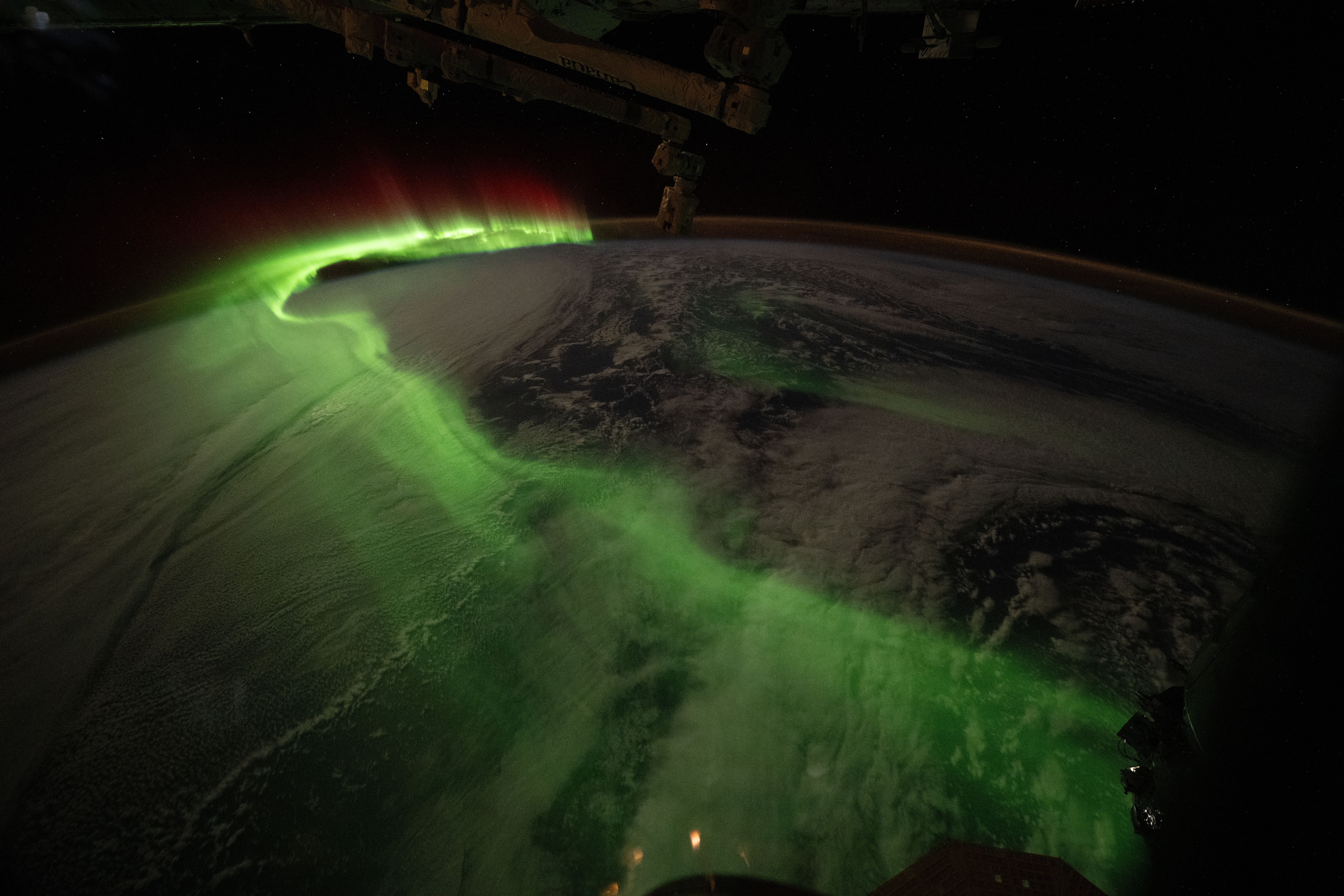
The aurora australis arcs over Earth during an active solar event in this photograph taken on June 5, 2026, from the International Space Station as it orbited 271 miles above the Indian Ocean southwest of Perth, Australia.
Auroras are colorful, dynamic, and often visually delicate displays of an intricate dance of particles and magnetism between the Sun and Earth called space weather.
Image credit: NASA/Jessica Meir
Aurora Australis
The aurora australis arcs over Earth during an active solar event in this photograph taken on June 5, 2026, from the International Space Station as it orbited 271 miles above the Indian Ocean southwest of Perth, Australia.
Auroras are colorful, dynamic, and often visually delicate displays of an intricate dance of particles and magnetism between the Sun and Earth called space weather.
Image credit: NASA/Jessica Meir
A quantum state that lasts forever may finally be within our grasp
A quantum state that lasts forever may finally be within our grasp
Are Alien Probes Hiding in Our Backyard? A New Study Says We’ve Barely Looked
Even at this early stage in our space faring age, humanity has already begun sending probes that will eventually reach other solar systems, even if that was not their original intention. Five robotic explorers - Pioneer 10 and 11, Voyager 1 and 2, and New Horizons - are all on escape velocities out of the solar system, and might someday enter another one. They will no longer be operational at that point, but they serve as a proof of concept that spacefaring civilizations do indeed build interstellar probes. Which raises the obvious question - has anyone else sent their own robotic explorers to ours? In a recent paper, published in the Proceedings of the IAU Centenary Symposium, astronomer T. Joseph W. Lazio, points out a painful truth - we still have no idea, and our technology will need to get much better if we plan to find out.