
NASA - Breaking News
NASA to Cover 34th SpaceX Resupply Mission Space Station Departure
NASA and its international partners are set to receive scientific research samples and hardware as a SpaceX Dragon spacecraft is scheduled to depart the International Space Station on Tuesday, June 16, for its return to Earth.
Watch NASA’s live undocking coverage beginning at 11:45 a.m. EDT on NASA+, Amazon Prime, and the agency’s YouTube channel. Learn how to watch NASA content through a variety of online platforms, including social media.
The Dragon spacecraft will undock from the forward port of the station’s Harmony module at about 12:05 p.m., after receiving a command from SpaceX ground controllers. The spacecraft then will fire its thrusters to move safely away from the orbiting complex.
Following a June 16 departure, the spacecraft will reenter Earth’s atmosphere on Wednesday, June 17, before splashing down off the coast of California at approximately 5:08 a.m. PDT. NASA will not stream the splashdown but will post updates on its space station blog.
Dragon will return to Earth with thousands of pounds of cargo, carrying samples that could shape future space exploration and life on Earth. Research returning includes bioprinted organ and cartilage tissue, data on improving cryogenic fuel storage for future space missions, and DNA‑inspired materials to develop new cancer treatments. The returning hardware includes an ocular imaging device used to monitor crew members’ eye health, an absorbent bed that filters trace contaminants from cabin air, and a separator pump from the waste and hygiene compartment.
Loaded with nearly 6,500 pounds of crew cargo and science experiments, Dragon arrived at the station on May 17 after launching two days earlier on a Falcon 9 rocket from Space Launch Complex 40 at Cape Canaveral Space Force Station in Florida.
For more than 25 years, people have lived and worked continuously aboard the International Space Station, advancing scientific knowledge and making research breakthroughs not possible on Earth. The space station helps NASA understand and overcome the challenges of human spaceflight, expand commercial opportunities in low Earth orbit, and build on the foundation for long-duration missions to the Moon, as part of the Artemis program, and to Mars.
Get breaking news, images, and features from the space station on Instagram, Facebook, and X.
Learn more about International Space Station research and operations at:
https://www.nasa.gov/international-space-station
-end-
Jimi Russell
Headquarters, Washington
202-358-1100
james.j.russell@nasa.gov
Leah Cheshier
Johnson Space Center, Houston
281-483-5111
leah.d.cheshier@nasa.gov
Black Eye Galaxy
This March 20, 2026, image of Messier 64, or the Black Eye Galaxy, is a composite view from NASA’s Hubble Space Telescope and James Webb Space Telescope. It shows Messier 64 captured at near- and mid-infrared wavelengths by Webb, while Hubble’s image shows the galaxy in ultraviolet, visible, and near-infrared light.
Messier 64 is characterized by its bizarre internal motion. The gas in the outer regions of this spiral galaxy is rotating in the opposite direction from the gas and stars in its inner regions. This strange behavior may be the result of a merger between M64 and a satellite galaxy over a billion years ago.
Image credit: NASA, CSA, ESA, F. Belfiore (European Southern Observatory – Germany), J. Lee (Space Telescope Science Institute), A. Leroy (The Ohio State University), and D. Thilker (The Johns Hopkins University); Processing: Gladys Kober (NASA/Catholic University of America)
Hubble Sees Swarm of Galaxies
- Hubble Home
- Overview
- Impact & Benefits
- Science
- Observatory
- Team
- Multimedia
- News
- More
2 min read
Hubble Sees Swarm of Galaxies This NASA Hubble Space Telescope image features the galaxy cluster MACS0329-0211. NASA, ESA, M. Postman (STScI); Image Processing: G. Kober (NASA/Catholic University of America)Looking somewhat like a swarm of bees returning to their hive, this NASA Hubble Space Telescope image features the galaxy cluster MACS0329-0211. Galaxy clusters like MACS0329-0211 are important signposts in the story of how the structure of the universe evolved, and are the ultimate telescopic lenses, placing gravitationally lensed galaxies from the earliest stages of the universe into our view.
Zoom into this galaxy swarm and you will find large, oval-shaped elliptical galaxies, and thin spiral and lenticular galaxies viewed from the edge. We can also see the full, face-on view of spiral galaxies and their curving spiral arms. The image’s upper-right quadrant holds faint arcs of distant galaxies gravitationally lensed by the cluster’s massive gravity. The largest of these arcs appears above the bright oval shape of a giant elliptical galaxy. Closer inspection of the image’s center reveals several bright-white intersecting curves that appear as a distorted figure eight. This may be another distant galaxy whose light was magnified and distorted by this massive cluster’s gravity.
Hubble looked at MACS0329-0211 as part of an observing program of X-ray bright galaxy clusters. Researchers used Hubble’s two main cameras, the Advanced Camera for Surveys and its Wide Field Camera 3, to gather data visible and infrared light from the cluster. Hubble’s ability to see such a broad spectrum of light makes it a valuable tool in understanding the very nature of these galaxy clusters.
Facebook logo @NASAHubble @NASAHubble Instagram logo @NASAHubbleMedia Contact:
Claire Andreoli
NASA’s Goddard Space Flight Center, Greenbelt, MD
claire.andreoli@nasa.gov
Since its 1990 launch, the Hubble Space Telescope has changed our fundamental understanding of the universe.
Hubble’s Galaxies
Hubble Science Highlights
Hubble Images
World Cup Fever in Guadalajara
- Earth
- Earth Observatory
- Image of the Day
- EO Explorer
- Topics
- More Content
- About
NASA Award Boosts Space Technology Research Capabilities
NASA is introducing a new funding opportunity to accelerate academic research and technology development. The Minority University Research and Education Project Space Technology Artemis Research (M‑STAR) application window opened Thursday and will remain open through 11:59 p.m. EDT on Tuesday, Aug. 11.
The research funded through this award supports the agency’s priorities for exploring the Moon, Mars, and deep space, while strengthening eligible institutions in the future of space exploration. Through M-STAR, institutions are encouraged to grow their scientific and engineering capabilities, enhance faculty and student engagement in aerospace research, and expand their ability to compete for future federal and commercial research awards.
Administered by NASA’s Office of STEM Engagement, this initiative contributes to NASA’s Space Technology Mission Directorate, and supports the agency’s broader mission to develop innovative technologies that improve space transportation, human exploration, robotic discovery, and the growing space economy.
NASA’s Office of STEM Engagement fosters an ecosystem across education, industry, and government to cultivate a well‑prepared talent pool, while the agency’s Space Technology Mission Directorate develops the transformative space technologies that enable future NASA missions and ensure U.S. leadership in aerospace. Together, they accelerate mission readiness by aligning cutting edge technological innovation with the workforce needed to carry it forward.
For complete eligibility information, help session registration, and to submit an M-STAR proposal, visit:
Keep Exploring Discover More Topics From NASAMinority University Research & Education Project
About STEM Engagement at NASA
Space Technology Mission Directorate
For Colleges and Universities
NASA’s Chandra Discovers Possible Supernova Remnant in Galactic Center
Using data from NASA’s Chandra X-ray Observatory, astronomers may have found a supernova remnant in an intriguing neighborhood in the middle of our galaxy. A paper describing these new findings published in The Astrophysical Journal.
Supernova remnants are the expanding remains of exploded stars and provide elements – like iron, oxygen, and silicon – that are critical for the formation of planets and for life as we know it to form and flourish.
This new supernova remnant, if confirmed, would be one of the closest ever discovered to the supermassive black hole at the central region of the Milky Way galaxy, an exotic region crammed with massive stars, long threads of magnetic fields and dense clouds of gas orbiting rapidly around the Galactic Center.
Astronomers may have uncovered a new supernova remnant in a star-forming region near the center of the Milky Way galaxy using data from Chandra and XMM-Newton. If confirmed, this would be one of the closest supernova remnants to the supermassive black hole in the Galactic Center. This image shows the region where the evidence was found, which contains X-rays from Chandra and XMM-Newton, radio data from the MeerKAT telescope in South Africa, and an optical image from the Pan-STARRS telescopes in Hawaii. X-ray: NASA/CXC/UCLA/Z. Zhu et al.; ESA/XMM-Newton; Optical: PanSTARRS; Radio: MeerKAT; Infrared (JWST): NASA/ESA/CSA/STScI; Image Processing: NASA/CXC/SAO/L. Frattare and P. EdmondsA new composite image of this region contains X-rays from Chandra and ESA’s (European Space Agency’s) XMM-Newton mission (shown in blue) as well as radio data from the MeerKAT telescope (shown in red) in South Africa. These have been combined with an optical image from the Pan-STARRS telescopes in Hawaii (red, green, and blue). The plane of the galaxy runs horizontally from left to right in the image, and the central black hole is off to the left of the image.
The evidence for the new supernova remnant, located about 26,000 light-years from Earth, comes from X-ray data from Chandra and XMM-Newton. The X-ray data reveals a “blob” of X-ray emission that may come from the remains of a massive star that self-destructed as a supernova, buried within the larger cloud of expanding gas.
The location of this suspected supernova remnant in the image is labeled with a circle.
It is in a bubble of gas that has had electrons stripped away from hydrogen – called an “H II region” – surrounding a massive, young star. This bubble is a bright source of radio emission called Sagittarius C.
If this is indeed a supernova remnant, then it is expanding at about two million miles per hour and is at least about 1,700 years old. Previously, observations with NASA’s now-retired SOFIA (Stratospheric Observatory for Infrared Astronomy) mission had shown evidence for an expanding shell of gas surrounding Sagittarius C. This gave astronomers a hint that a stellar explosion had occurred in the same spot.
The long filaments seen in the radio image are caused by energetic particles travelling along magnetic fields that are mostly directed perpendicular to the plane of the galaxy.
The nuclear fusion engines of stars create elements from hydrogen and helium that were abundant at the beginning of the universe. When stars explode at the end of their lives as supernovae, they send these newly synthesized elements into interstellar space and provide material for the next generation of stars and planets.
The team of astronomers searched the X-ray data for signs of increased amounts of key elements in the remnant, which would have been caused by the stellar explosion blasting them into space. While they did not see an enhancement, this could imply that the stellar debris has already mixed with the surrounding gas.
An alternative explanation for the X-ray blob is that the hot gas comes from a collection of massive stars in the region. The authors of the recent study don’t think this explanation is likely, because the X-ray emission from the blob is more than ten times brighter than the X-ray emission of large, known stellar clusters with bright, massive stars.
An additional image shows data from NASA’s James Webb Space Telescope added to the X-ray and radio data. The light blue color represents infrared light from gas in the H II region, and the darker blue depicts X-rays from the supernova remnant candidate, on the right side of the image. X-rays near the center of the image are associated with the H II region, possibly caused by material blown away by massive stars that has heated gas to millions of degrees, producing X-rays.
Sagittarius C, close-up image adding NASA’s James Webb Space Telescope data to the X-ray and radio data.The study’s authors are Zhenlin Zhu and Mark Morris of the University of California, Los Angeles; Gabriele Ponti of Italy’s National Institute for Astrophysics; and Ping Zhou of Nanjing University in China.
NASA’s Marshall Space Flight Center in Huntsville, Alabama, manages the Chandra program. The Smithsonian Astrophysical Observatory’s Chandra X-ray Center controls science operations from Cambridge, Massachusetts, and flight operations from Burlington, Massachusetts.
Visual DescriptionThis release features a composite image of colorful, overlapping clouds, which suggests to astronomers that a supernova remnant may be buried in gas near the center of our Milky Way galaxy.
Set against a backdrop packed with distant stars and other specks of light are two distinct, overlapping clouds. The larger, visually dominant cloud, is red and multifaceted. It has an irregular shape, and features patches of different textures, including pockets that resemble wispy smoke, tangles of faint red veins, and clear streaking lines. This large cloud of expanding gas represents radio data from the MeerKAT telescope in South Africa.
Overlapping with that red cloud is a cloudy blue blob representing X-ray data from NASA’s Chandra X-ray Observatory and ESA’s XMM-Newton. Astronomers suggest that this blue blob of X-ray emissions is the remains of a massive star destroyed by a supernova.
Read more from NASA’s Chandra X-ray Observatory
To learn more about NASA’s Chandra mission, visit:
https://science.nasa.gov/chandra
News Media ContactMegan Watzke
Chandra X-ray Center
Cambridge, Mass.
617-496-7998
mwatzke@cfa.harvard.edu
Joel Wallace
Marshall Space Flight Center, Huntsville, Alabama
256-544-0034
joel.w.wallace@nasa.gov
Share
Details Last Updated Jun 12, 2026 Editor Lee Mohon Contact Joel Wallace Location Marshall Space Flight Center Related Terms Explore More 4 min read NASA Connects Little Red Dots with Chandra, WebbArticle
2 months ago
5 min read NASA Finds Young Stars Dim in X-rays Surprisingly Quickly
Article
2 months ago
6 min read NASA Discovers Crash of Extreme Stars in Unexpected Site
A fleet of NASA missions has likely uncovered a collision between two ultradense stars in…
Article
3 months ago
Keep Exploring Discover More Topics From NASA
Chandra X-ray Observatory
IXPE
The Imaging X-ray Polarimetry Explorer (IXPE) is NASA’s first mission to study the polarization of X-rays.
James Webb Space Telescope
Webb is the premier observatory of the next decade, serving thousands of astronomers worldwide. It studies every phase in the…
Hubble Space Telescope
Since its 1990 launch, the Hubble Space Telescope has changed our fundamental understanding of the universe.
I Am Artemis: Elkin Norena
Listen to this audio excerpt from Elkin Norena, resident management officer, NASA’s Space Launch System Program:
0:00 / 0:00
Your browser does not support the audio element.NASA’s Elkin Norena has helped the agency launch more than a dozen space shuttle missions – that’s more than a dozen crews to low Earth orbit and more than a dozen historic missions. They were missions that helped build the International Space Station, that provided a final servicing mission to the Hubble Space Telescope, and that performed critical science experiments that improved life right here on Earth.
Today, he continues that work as the manager of the Resident Management Office for SLS at NASA’s Kennedy Space Center in Florida, helping launch America’s rocket – the SLS (Space Launch System) – and the Orion spacecraft with its international quartet of astronauts on the Artemis II mission to fly by the Moon and return home.
Elkin Norena, who serves as an SLS resident management officer at NASA’s Kennedy Space Center in Florida, stands in front of an RS-25 engine.NASAAs resident manager, Norena provides onsite SLS support for NASA’s Exploration Ground Systems team that is responsible for preparing, stacking, testing, and launching SLS and Orion. He is also the eyes and ears for the SLS Program, providing an avenue of communications back to the program, which is managed at NASA’s Marshall Space Flight Center in Huntsville, Alabama.
It is the continuation of a childhood dream to be part of space exploration.
“When I was a kid in New Jersey, I watched a space shuttle launch in class one day,” said Norena. “When I watched the power of launch and the brave astronauts going to explore, I knew I had to be a part of that one day. I wanted to become an astronaut.”
The dream to join the space program led the Colombia native to the University of Central Florida in Orlando, where he majored in computer engineering, just miles from the Space Coast and in view of space shuttle launches like the ones he once watched on TV.
When that clock ticks down to T-10 minutes, everybody’s just waiting. You wait for the automated system to kick in. You hold your breath and watch the clock go down to T-0. Then BOOM, launch happens, and you know it was all worth it.Elkin Norena
Resident management officer, NASA Space Launch System Program
Following college, he joined NASA contractor United Space Alliance at NASA Kennedy, and in 2008 he joined the NASA Kennedy team as a civil servant, working on the same spacecraft that inspired him to pursue the space program as a child.
“I started off in the Space Shuttle Program as an electrical engineer. Then I moved into the firing room for 17 different shuttle missions as a flight termination engineer. It was exciting to be part of all those missions and build the International Space Station,” Norena said.
The Milky Way stretches above Dry Tortugas National Park in Florida. Elkin NorenaUsing those experiences, he became one of the original SLS team members. He was a part of the teams that successfully launched Artemis I and II and is now critical to the upcoming Artemis III mission.
Away from the launch pad, Norena’s hobbies orbit around his teenage daughters, participating in their activities. He also keeps a keen eye on space and is an avid astrophotographer.
“I love capturing the Milky Way! I’ve traveled to Utah, New Mexico, Arizona, and all across the western United States,” he said. “A great spot that’s closer for me is Dry Tortugas National Park beyond Key West.”
No matter how he explores space, Norena believes Artemis II is more than just a mission.
“This is historic. I grew up watching the shuttle missions, learning about Apollo, and wanting to be part of those Moon missions. We built the space station. The space shuttle explored space and technology on many levels,” he said. “Now, it’s our turn with Artemis to get back to the Moon, and this time to stay there. I’m excited to be part of the generation that does that.”
About the AuthorWilliam BryanCommunication Strategist Share Details Last Updated Jun 11, 2026 EditorLee MohonContactJonathan Dealjonathan.e.deal@nasa.govLocationMarshall Space Flight Center Related Terms Explore More 3 min read I Am Artemis: Doug Parkinson Article 4 months ago 4 min read I Am Artemis: Jacki Mahaffey Article 5 months ago 3 min read I Am Artemis: Lili VillarrealLili Villarreal fell in love with space exploration from an early age when her and…
Article 1 year ago Keep Exploring Discover More Topics From NASAMissions
Humans in Space
Climate Change
Solar System
NASA Robotic Tech Demo Will Advance Prototype Gamma-Ray Detectors
4 min read
NASA Robotic Tech Demo Will Advance Prototype Gamma-Ray DetectorsA new type of gamma-ray sensor developed by NASA, called AstroPix, will take part in a robotic arm demonstration on the agency’s upcoming Fly Foundational Robots mission, set to launch in late 2027.
Gamma rays are the highest-energy form of light. Scientists observe them coming from events like lightning in Earth’s atmosphere, powerful solar flares from our Sun, and cosmic collisions in distant galaxies. The sensors on the AstroPix technology demonstration are designed to measure gamma rays between 20,000 and 700,000 electron volts. For comparison, visible light’s energy falls between 2 and 3 electron volts.
Current NASA missions, including the Fermi Gamma-ray Space Telescope and Neil Gehrels Swift Observatory, also observe gamma rays, including those with even higher energies.
But for energies between 500,000 to 1 million electron volts, existing detectors are less sensitive. This range is where many powerful explosions called gamma-ray bursts shine the brightest. It’s also where astronomers expect to see the strongest glow from the most massive and distant active galaxies powered by black holes. By stacking AstroPix detectors in future missions, scientists could bridge this gap and improve observations of these cosmic objects to better understand the processes that create and drive them.
“The Fly Foundational Robots spacecraft is also a technology demonstration, so the projects were a good fit for each other,” said Dan Violette, an AstroPix team member and post-doctoral fellow at NASA’s Goddard Space Flight Center in Greenbelt, Maryland. “We need to thoroughly test AstroPix’s performance before we can use the sensors in future science missions. We’ve flown comparable technologies on a scientific balloon mission, and the current prototype eventually will be part of a sounding rocket payload. Many of those flight opportunities only reach near space, though. It’s not often that technology demonstrations like ours can find a ride into orbit.”
Each AstroPix chip has four silicon pixel gamma-ray detectors. Each of these detectors incorporates 1,225 pixels. AstroPix detectors, which are developed by NASA’s Goddard Space Flight Center in Greenbelt, Md., function similarly to the sensors in cellphone cameras except they are sensitive to gamma-ray light. Image courtesy of Argonne National LaboratoryEach AstroPix chip contains four silicon pixel gamma-ray detectors, and each detector incorporates 1,225 pixels. The chips function similarly to the sensors in cell phone cameras.
The AstroPix Satellite Technology dEmonstration Payload, also known as A-STEP, will be hosted within the Fly Foundational Robots mission’s Orbital Replacement Unit, a movable module built by Rocket Lab Robotics. Rocket Lab Robotics also will provide a robotic arm that will pick up and reposition the unit during flight and perform in-orbit operations as part of a robotic servicing demonstration. The A-STEP payload will collect its data following the repositioning. Astro Digital will provide the spacecraft.
The Orbital Replacement Unit was designed to support power and data interfaces for a payload, but the original plan called for the robotic arm to reposition the module without one. As mission development progressed, however, the Fly Foundational Robots team identified an opportunity to further maximize the mission’s value by integrating an additional technology demonstration that could fit within the 11.8-inch (30-centimeter) cube.
“The unit already had the volume, power, and data needed to support the AstroPix team’s design,” said Bo Naasz, senior technical lead, In-space Servicing, Assembly, and Manufacturing in the Space Technology Mission Directorate at NASA Headquarters in Washington. “One of our major goals with Fly Foundational Robots is to demonstrate robotic changeout of payloads in orbit, enabling upgrades or improvements to satellites and space instruments at a fraction of the cost of a full mission. Allowing AstroPix to complete its own technology demonstration in orbit is a bonus.”
NASA’s Fly Foundational Robots mission will be hosted aboard a spacecraft provided by Astro Digital of Littleton, Colo., as shown in this artist’s concept. The robotic arm, provided by Motiv Space Systems in Pasadena, Calif., will perform a technology demonstration in orbit, including picking up and moving a small box containing the agency’s AstroPix gamma-ray sensors. Rocket Lab RoboticsThe AstroPix team is working to deliver their hardware this September, and it will be integrated into the Fly Foundational Robots payload before final integration onto the spacecraft. The Orbital Replacement Unit will hold the chips and all the associated electronics needed to provide power, and collect and transmit data during flight.
NASA’s Fly Foundational Robots mission is funded through the Space Technology Mission Directorate’s ISAM portfolio, managed at NASA Goddard. Rocket Lab Robotics will supply the mission’s robotic arm system through a NASA Small Business Innovation Research Phase III award. Astro Digital will host the orbital flight test of the arm through NASA’s Flight Opportunities program, managed at NASA’s Armstrong Flight Research Center in Edwards, California. The development of AstroPix was supported by NASA’s Astrophysics Division in the Science Mission Directorate at NASA Headquarters, through the agency’s Astrophysics Research and Analysis Program, and funded through the Nancy Grace Roman Technology Fellowship.
To learn more, visit:
By Jeanette Kazmierczak
Goddard Space Flight Center, Greenbelt, Md.
Soccer Meets Space Science
A soccer ball floats in microgravity in this March 2, 2026, picture from the International Space Station. The space station crew tested soccer balls to study how internal mass affects motion and stability in microgravity. The findings have improved understanding of how embedded technologies, including match-ball sensors, can influence performance during play.
Through research aboard the International Space Station and technology developed for exploration, NASA continues to demonstrate how discoveries made for space can benefit people on Earth—including athletes and fans participating in the world’s most popular sport.
Image credit: NASA
NASA’s Career Technical Education Day Highlights Technical Careers
3 min read
Preparations for Next Moonwalk Simulations Underway (and Underwater) Students participate in a hands-on robotics demonstration during Career Technical Education Day at NASA’s Langley Research Center in Hampton, Virginia. NASA/Mark KnoppAt NASA, remaining a global leader in exploration and innovation includes having a skilled
and dedicated workforce. Technicians play a critical role in advancing the agency’s
research and missions, applying hands-on expertise across engineering, fabrication,
electronics, and countless other technical fields.
To help cultivate the next generation of technical talent, NASA’s Office of STEM Engagement
hosted Career Technical Education Day recently at NASA’s Langley Research Center in
Hampton, Virginia. One hundred high school and community college students from Virginia
and North Carolina attended, eager to explore the technical career paths that help drive
NASA’s work.
“Many students picture NASA as only astronauts or engineers and therefore never consider
a career at NASA to be within their reach,” said Bonnie Murray, lead for the Office of STEM
Engagement at NASA Langley. “Bringing students from local career and technical
education programs to Langley allows them the opportunity to see technicians at work,
hear the pathways those technicians followed, and understand how the skills they are
developing in their related classes have a place in the NASA workforce.”
The event opened with remarks from NASA Langley’s Steve Gayle, who traced his path from
an engineering technician co-op in the center’s Fabrication Division and a graduate of
Langley’s Engineering Technician Apprentice Program to his current role as acting
associate director. Gayle encouraged students to embrace challenges, think critically, stay
curious, and create their own opportunities as they pursue their career goals.
“We need young, bright minds,” Gayle said. “At NASA, we rely on skilled hands-on
professionals — technicians who operate our wind tunnels, apply their skills in our
fabrication shops, and use their electronics knowledge to design, test, and build critical
systems.”
Throughout the day, students toured several of Langley’s world-class facilities, including
the historic Landing and Impact Research Facility and one of the center’s wind tunnels. At
each stop, they received a behind-the-scenes look at the spaces where NASA technicians
build, test, and refine the tools and technologies that support the agency’s missions. The
technicians spoke with students about their work, their career paths, and the skills needed
to excel in technical roles.
Hands-on demonstrations and interactive activities lead by NASA technicians and
aerospace industry partners helped students connect their classroom experience with
real-world applications. Whether observing fabrication techniques, seeing instrumentation
up close, or engaging with engineering demonstrations, participants experienced how
STEM and technical skills directly translate into meaningful careers.
“Through events such as this, NASA seeks to prepare students for aerospace careers
through experiences and investments that strengthen research capacity, build technical
expertise, and expand reach in alignment with agency missions and needs,” Murray said.
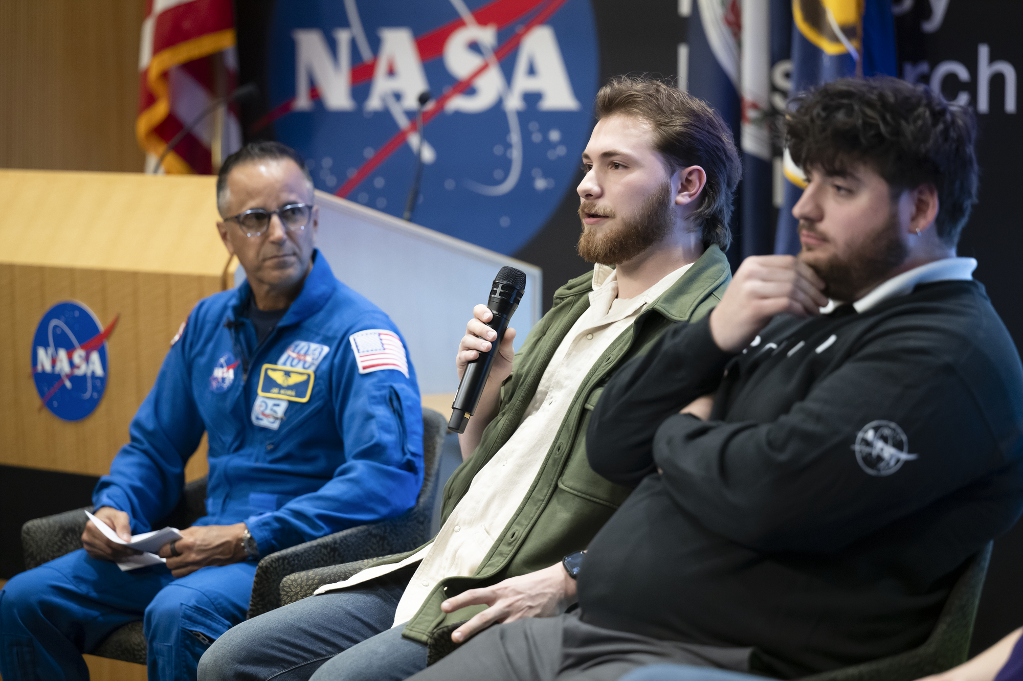
The event ended with a career panel moderated by NASA astronaut Joe Acaba, associate
director of mission and strategy at NASA’s Johnson Space Center in Houston and former
math and science teacher. The panel featured four Langley technician apprentices who
shared insights into their roles and the value of strong foundational skills in technical
fields.
“A basic grasp of how software, systems, and even everyday items function goes a long way
as you progress in your technician journey,” said Wyatt Healy, mechanical engineering
technician apprentice at NASA Langley. “When you have those fundamentals down,
learning the more advanced concepts becomes much easier. It doesn’t happen overnight,
but with a strong foundation, the sky is the limit.”
By connecting students with NASA professionals, facilities, and hands-on experiences, the
event showcased a broad range of opportunities available in technical careers. It also
underscored NASA’s commitment to building a strong, skilled workforce equipped to
support the agency’s mission and tackle the challenges of tomorrow.
For more information about opportunities to connect students with NASA’s mission, work, and people, visit:
https://www.nasa.gov/learning-resources
Brittny McGraw
NASA Langley Research Center
Missions
Humans in Space
Climate Change
Solar System
NASA, USGS Scientists Go Rock Hounding in California’s High Desert
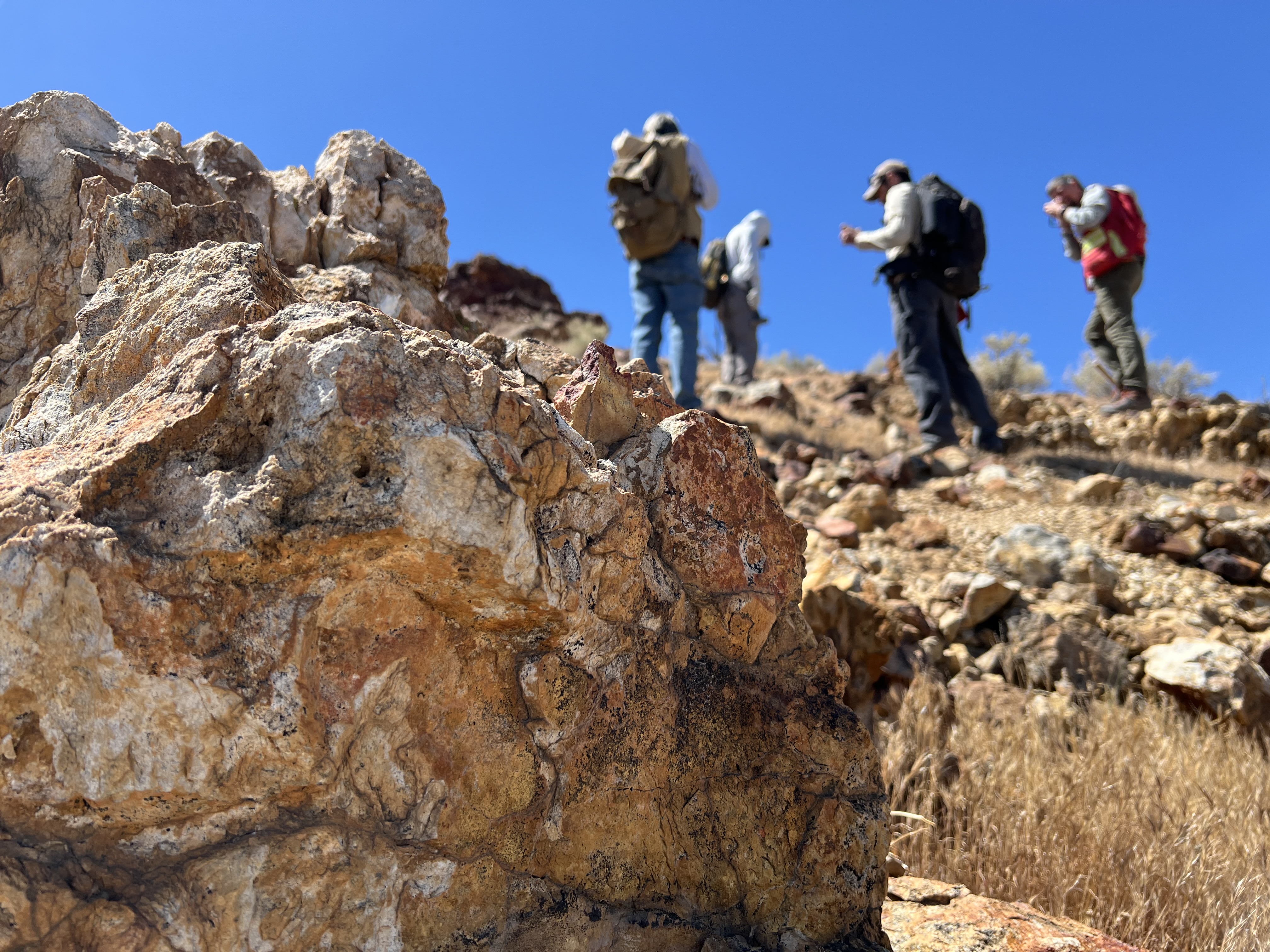
Equipped with rock picks and hand lenses, a team of geoscientists deployed to the Mojave Desert recently to investigate a tantalizing “fingerprint” detected by a NASA sensor. Their target: a cache of topaz hiding in plain sight.
The geologists weren’t searching for gem-grade treasure. Rather, the presence of topaz could hint at a more valuable deposit below of something known as porphyry copper.
One of the world’s primary sources of copper, these deposits are left behind when magma and hot water from deep underground course through Earth’s crust, chemically transforming the surrounding rock. This tends to occur where one tectonic plate dives below another, known as a subduction zone, such as the North American Cordillera, which stretches from the Canadian Rockies to western Mexico.
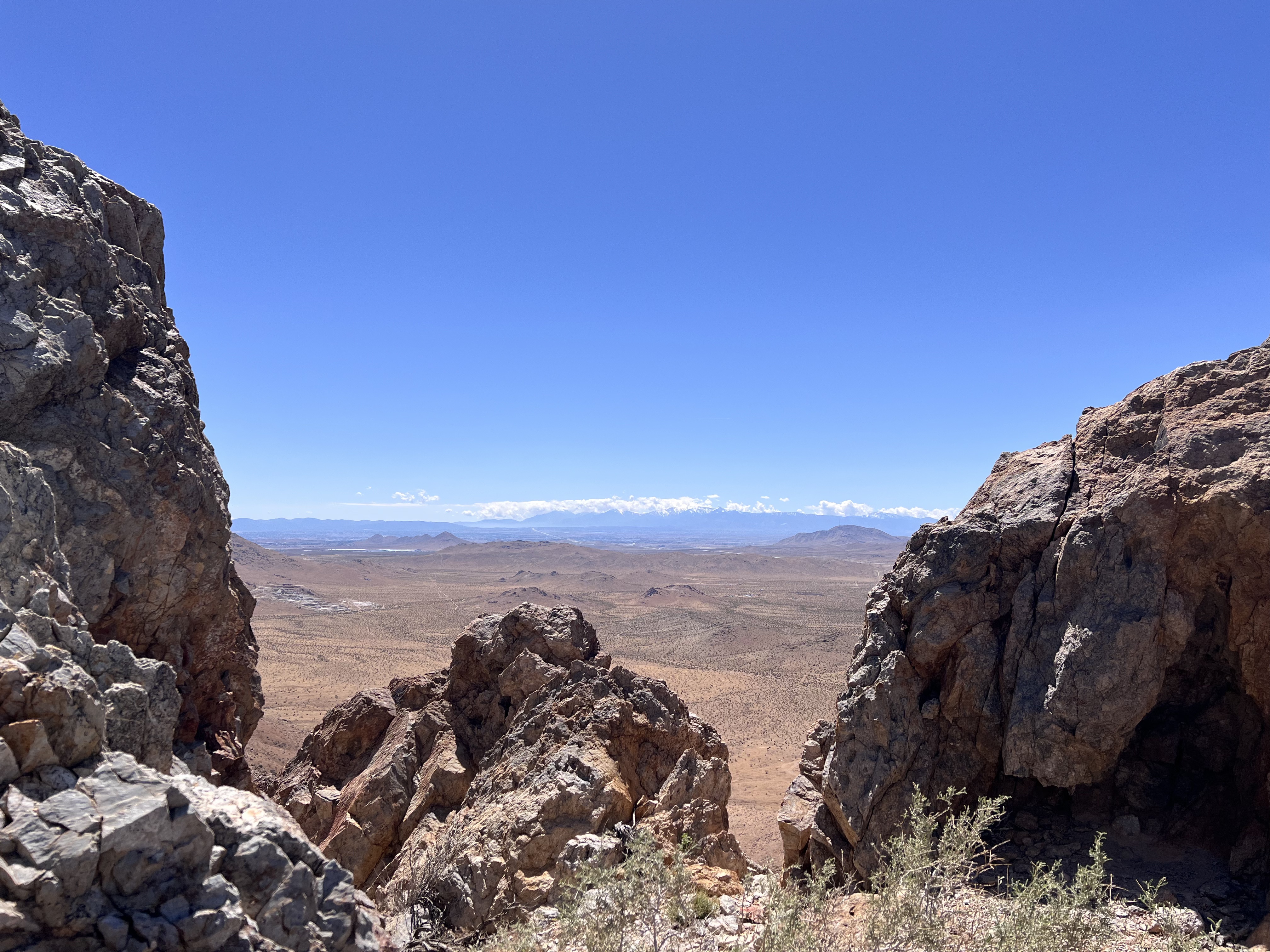
California’s high desert stretches below a bright spring sky in April 2026. NASA and USGS scientists are using airborne remote sensing to home in on potential sources of critical minerals here and across the Western U.S.NASA/JPL-CaltechIn addition to copper — the third most used metal in the world after steel and aluminum — the deposits can hold other critical minerals like molybdenum and tellurium, which are used in everything from steelmaking to solar panels. Finding the deposits isn’t easy. Geologists look for topaz because it forms under the same volcanic conditions.
For the team in the Mojave, the goal was to collect more evidence. That would require boots on the ground and a heavy bag of samples. The scientists who converged on the site included three experts from the U.S. Geological Survey (USGS) and Robert Green of NASA’s Jet Propulsion Laboratory in Southern California.
“What we’re doing out here is geologic CSI,” said Green, referring to the investigative TV show, as he split open a weathered red rock to expose a sparkling core. “We’re looking for clues to reconstruct what happened here.”
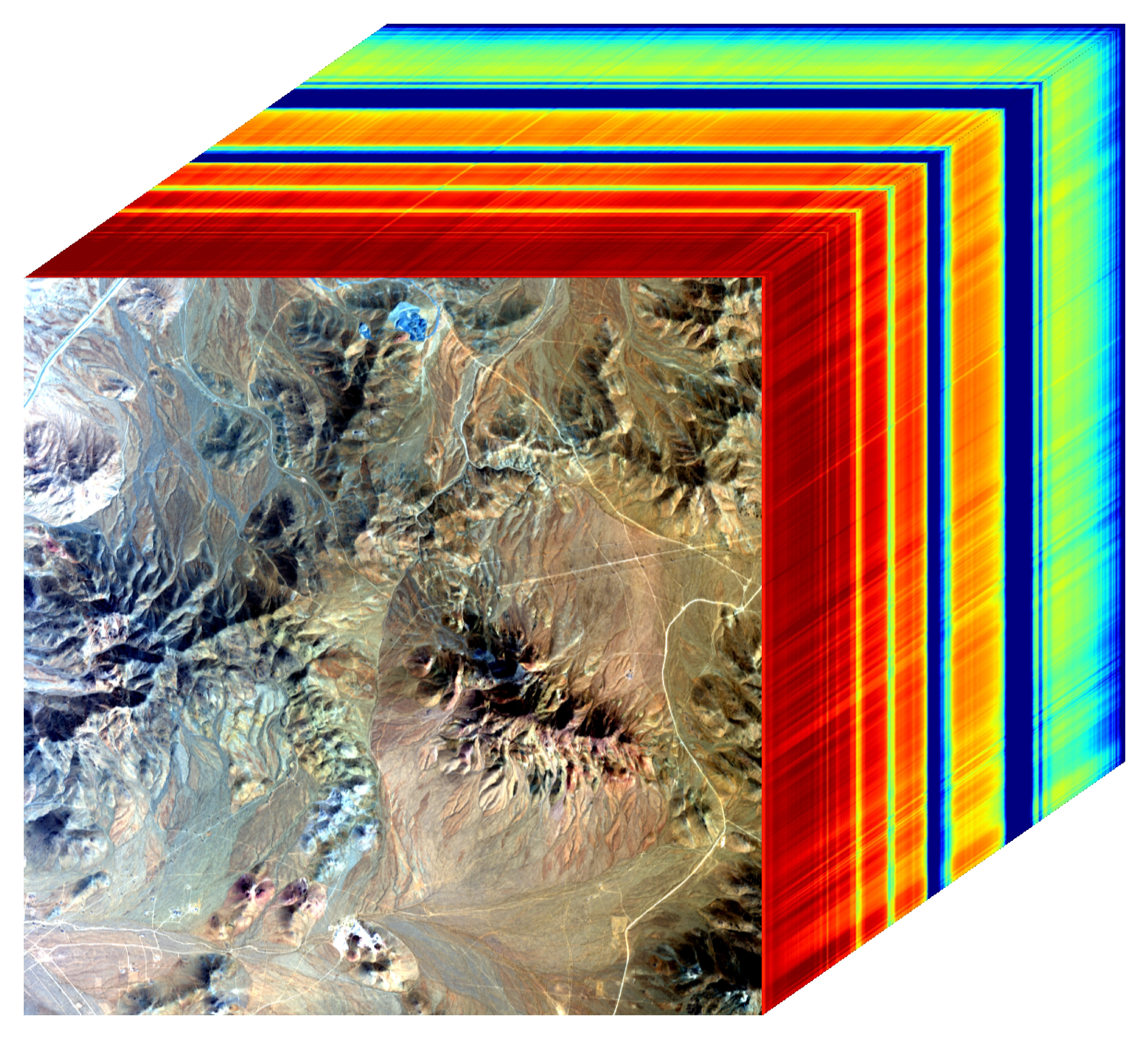
Three-dimensional image cubes illustrate the volume of data captured by NASA imaging spectrometers. The front face shows an aerial view of the Mojave Desert. The colorful side panels reveal what no eye or camera can detect: the spectral fingerprints of minerals present in every pixel.NASA/JPL-Caltech Next-generation mineral mappingThe sensor that detected the topaz deposit on public land near Barstow, California, was built at JPL. Called AVIRIS, short for Airborne Visible Infrared Imaging Spectrometer, it analyzes reflected sunlight and can be used to identify chemicals and minerals by their unique spectral fingerprint. The technology was pioneered in the early 1980s by a team that included Green, and space-hardened versions have explored the Moon, Mars, and other rocky bodies in the solar system in the decades since.
While its cousins study distant worlds aboard spacecraft, the AVIRIS line of sensors is advancing Earth science from aircraft. The latest model, AVIRIS-5, recently took to the skies for the first time as part of the NASA-USGS Geologic Earth Mapping Experiment (GEMx). The goal of GEMx is to identify sources of critical minerals across the American West, including in the waste rock of active and legacy mines. It is led by the USGS as part of its larger, nationwide initiative.
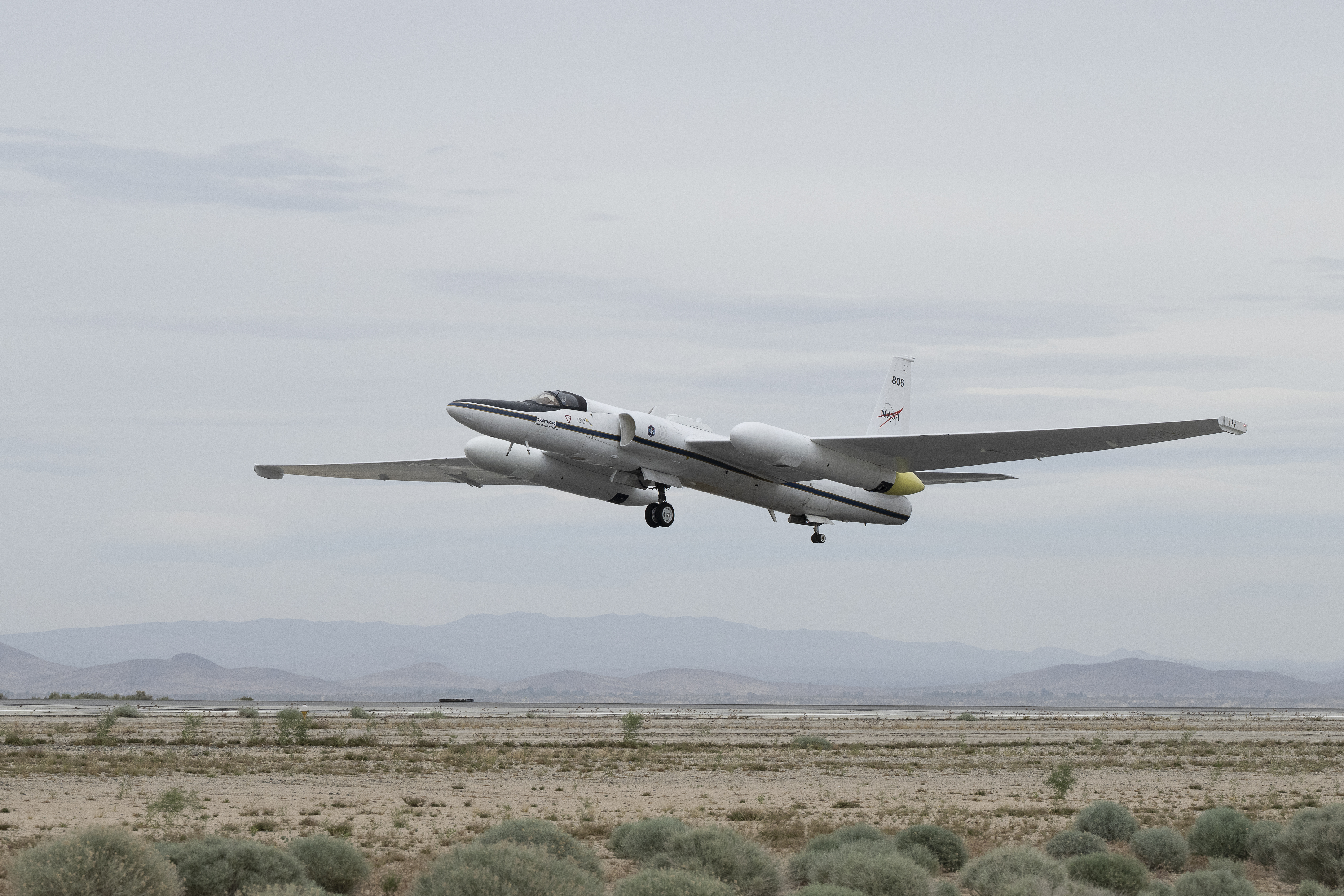
Carrying next-generation sensors, a high-altitude NASA ER-2 aircraft takes off from the agency’s Armstrong Flight Research Center in Edwards, California, on March 31, 2026, to support the GEMx mineral mapping campaign.NASA/Carla ThomasSince 2023, GEMx flights have covered more than 386,000 square miles (1 million square kilometers) of American soil, including most of California.
Ground-truthing the sensor data can entail hot field work, scrambling over steep crags to uncover samples for lab analysis. While testing has confirmed the topaz discovery, determining if the Mojave site overlies a porphyry copper deposit will require intensive investigation using ground-penetrating equipment. But the AVIRIS finding shows how advanced NASA airborne sensing can help lead geologists to the metaphorical needle in a haystack, even in heavily explored Southern California.
“People have been prospecting this area for generations,” said Erik Tharalson, a USGS geologist. “But there’s a lot more to discover.”
High flyerFrom the beginning, the GEMx mineral mapping campaign has been enabled by one of the highest-flying aircraft in NASA’s fleet: the ER‑2. It deployed on March 31 from NASA’s Armstrong Flight Research Center in Edwards, California, to Colorado Springs Airport in Colorado.
“We deployed to Colorado Springs to maximize flight time for data collection needed in Colorado, Utah, New Mexico, Arizona, and Texas,” said John McGrath, ER‑2 project manager at NASA Armstrong.
By the conclusion of this deployment on June 5, the aircraft had completed 26 flights totaling more than 125 hours. Soaring at about 65,000 feet, the ER-2 can fly at high altitudes that allow it to collect broad‑area, high‑resolution spectral measurements in a single pass, supporting researchers studying mineral composition and surface processes.
In 2025, the aircraft flew 36 science missions, collecting more than 7 billion measurements over 200 flight hours. The data has contributed to the largest airborne surface mineralogy dataset gathered in a single NASA-USGS campaign.
The GEMx survey is led and funded by the USGS Earth Mapping Resources Initiative. Earth MRI is modernizing mapping the nation’s surface and subsurface to find new, critical, and other minerals. It is a partnership effort with 45 state geological surveys, federal agencies, private industry, tribes, universities, and others. The initiative will capitalize on both the technology developed by NASA for spectroscopic imaging, as well as the USGS expertise in analyzing the datasets, conducting field work, and deriving critical mineral information from them.
To learn more about GEMx visit:
https://science.nasa.gov/mission/gemx/
Media Contacts
Andrew Wang / Andrew Good
Jet Propulsion Laboratory, Pasadena, Calif.
626-379-6874 / 818-393-2433
andrew.wang@jpl.nasa.gov / andrew.c.good@jpl.nasa.gov
Written by Sally Younger
2026-037
Explore More 5 min read World Cup Fever in GuadalajaraThe city’s metro area has pushed westward since it last hosted World Cup matches in…
Article 2 hours ago 6 min read Air Pollution’s Daily Pulse Over the NortheastThe TEMPO mission helped scientists track morning nitrogen dioxide that contributed to afternoon ozone along…
Article 1 day ago 2 min read NASA, NOAA to Hold Joint Session at 23rd Symposium on Operational Environmental Satellite SystemsAbstracts are now being accepted for the session, which will take place at the 2027…
Article 2 days ago Keep Exploring Discover More Topics From NASAGEMx
Armstrong Flight Research Center
Jet Propulsion Laboratory
Earth Science – Technology
NASA to Preview Katalyst Mission to Boost Swift Spacecraft’s Orbit
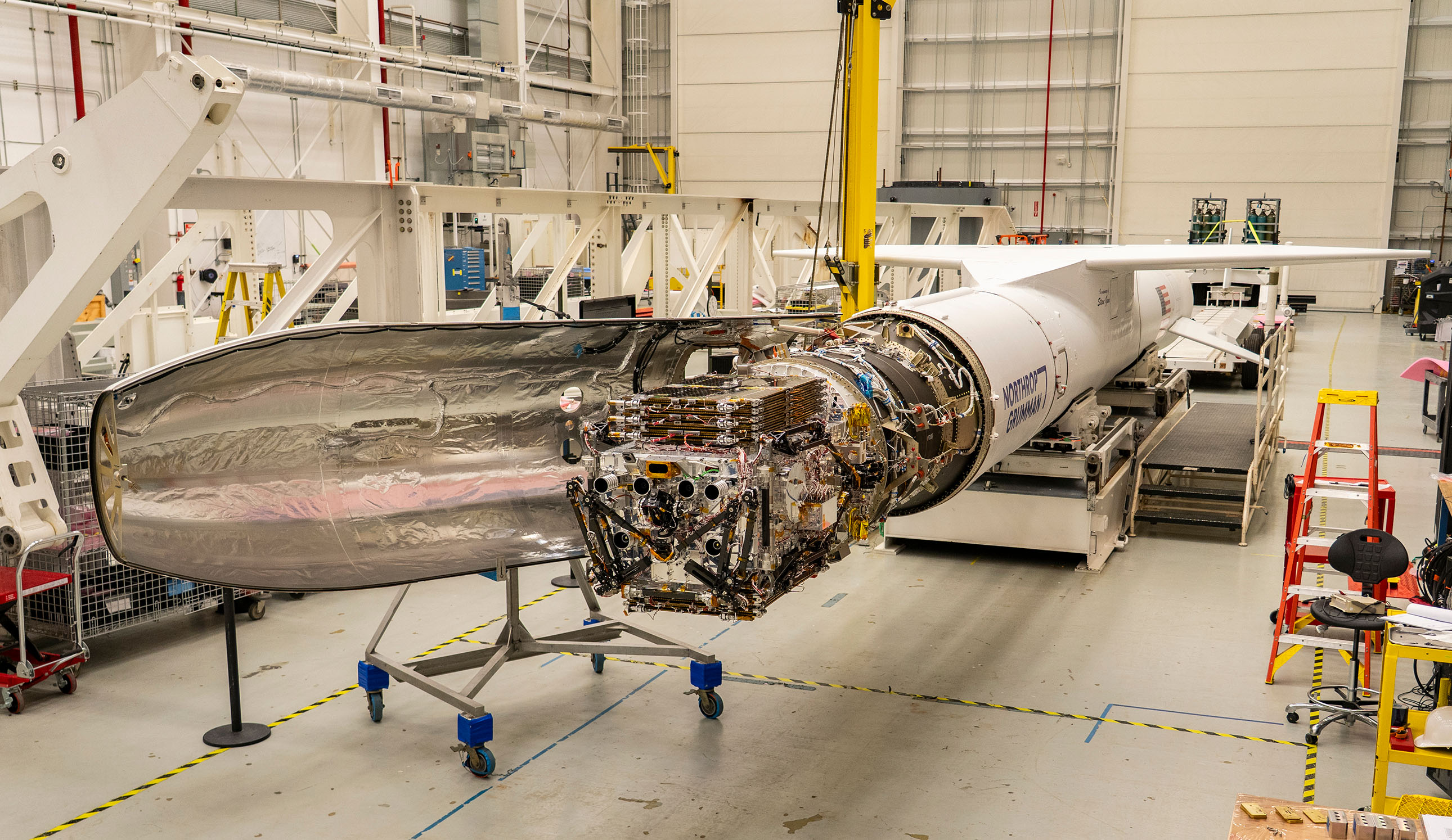
NASA will host an audio-only media teleconference at 11 a.m. EDT, Wednesday, June 17, to preview the Katalyst Space mission to boost the orbit of NASA’s Neil Gehrels Swift Observatory.
Katalyst’s robotic servicing spacecraft, called LINK, will attempt to rendezvous with Swift and raise its altitude, extending its science mission lifespan and advancing a key capability for the future of space exploration. The LINK spacecraft will launch on Northrop Grumman’s Pegasus XL rocket later this month from Kwajalein Atoll in the Marshall Islands.
Media interested in participating by phone must RSVP no later than two hours before the start of the call to Amy Barra at: amy.l.barra@nasa.gov. NASA’s media accreditation policy is available online.
Audio of the media teleconference will stream on the agency’s website at:
Participants in the media teleconference include:
- Shawn Domagal-Goldman, division director, Astrophysics, NASA Headquarters in Washington
- Brad Cenko, principal investigator, Swift, NASA’s Goddard Space Flight Center in Greenbelt, Maryland
- Kieran Wilson, principal investigator, LINK, Katalyst Space
- Robert Lamontagne, vice president, strategic partnerships, Katalyst Space
- Wes Collier, vice president, launch systems, Northrop Grumman
The Swift mission, which launched in 2004, leads NASA’s fleet of telescopes in studying changes in the high-energy universe, like gamma-ray bursts, which are the most powerful explosions in the cosmos. When a rapid, sudden event takes place in the sky, Swift serves as a “dispatcher,” providing critical information that allows other “first responder” missions to follow up to learn more about how the universe works.
After 21 years, Swift’s low Earth orbit has begun to rapidly decay because of increased solar activity. Rather than allowing the observatory to re-enter Earth’s atmosphere, as many missions do at the end of their lifetimes, NASA is using this opportunity to advance U.S. spacecraft servicing technology. In September 2025, NASA awarded a contract to Katalyst to mount a robotic servicing mission for Swift in less than a year. The mission will use LINK to rendezvous with Swift and boost it to a higher altitude, demonstrating a key capability for the future of space exploration. The mission is targeted for launch in June from Kwajalein Atoll, Marshall Islands.
Learn more about the mission to boost Swift’s orbit at:
https://science.nasa.gov/mission/swift/swift-boost-mission/
-end-
Karen Fox / Alise Fisher
Headquarters, Washington
202-385-1287 / 202-358-2546
karen.c.fox@nasa.gov / alise.m.fisher@nasa.gov
Amy Barra
Wallops Flight Facility, Wallops Island, Va.
757-824-1579
amy.l.barra@nasa.gov
Air Pollution’s Daily Pulse Over the Northeast
- Earth
- Earth Observatory
- Image of the Day
- EO Explorer
- Topics
- More Content
- About
Curiosity Blog: Sols 4913-4919: Planetary explorers, freewheeling to the Yardang unit!
- Curiosity Home
- Science
- News and Features
- Multimedia
- Mars Missions
- Mars Home
3 min read
Curiosity Blog: Sols 4913-4919: Planetary explorers, freewheeling to the Yardang unit! Navcam image from sol 4916 showing the rough drive direction. The yardang unit can be seen as a series of pale coloured hills in the centre of the image, at the very back. NASA/JPL-CaltechWritten by Catherine O’Connell-Cooper, APXS Strategic Planner and Payload Uplink/Downlink Lead, University of New Brunswick, Canada
Earth planning day: Friday, June 5th, 2026
In a very broad sense, Curiosity has two modes of doing science – one centred around a defined science campaign (such as the recent boxwork campaign) and the other as we move between campaigns. During a science campaign, with a very defined start and end location, every image and every workspace is carefully choregraphed to make sure we hit all of our science goals for the campaign. This is a lot of pressure!
But in between campaigns, the emphasis moves to driving towards the next major campaign. Our next major stop is the yardang unit, a series of intriguing wind sculpted, pale coloured hills which you can just see in the distance in the cover image for this blog. The rover planners (RPs) sometimes make our drives as long as they can and we drive as far as we can go, other times we stop a little short to look at interesting looking workspaces as we go. As part of the APXS team, I loved being part of the boxwork campaign and getting all the information we needed there … but as a geologist, there is something very special about this kind of exploring, the sense of being a planetary explorer, ambling along to see what the rocks will show us.
So we continue southwards, trundling over laminated bedrock which varies from predominantly pale coloured laminated bedrock to bands with abundant thin flaky, darker coloured, layers and patches. Some of the rocks stick out at strange angles, which make planning drives more challenging. This past week there has been abundant dark layers interbedded with the more dominant pale coloured rock, both in place and in fragments around the workspace. APXS and MAHLI characterized some of this darker material, for example at “Rio Bio Bio” and “Placilla de Caracoles” and some of the paler material at the brushed targets “La Primavera” and “Los Quemados.” ChemCam also analyzed both types of rocks along the way.
We are busily acquiring Mastcam and ChemCam LD-RMI (“Long Distance Remote Micro Imager”) images of everything even remotely interesting – and there are lots and lots of cool features around here. The wide open landscape here allows us to image features from several different angles and distances, such as “Mira Flores,” a small erosional outlier seen from a distance in this image and closer up here. Another great example is the “Kimsa Chata” trough which shows some amazing sedimentary structures, which may help us to determine if this was a desert or a lake or maybe something in between, such as a desert with some water moving through.
The Environmental Theme Group continues to populate each plan with environmental monitoring activities. Activities varied from dust devil monitoring in Gale crater to looking at levels of dust in the skies overhead. The weekend drive is planned to take us further into that drive distance shown in the cover image, to an area where the contrast between dark and light bedrock is more pronounced, and just beyond that, to an area which looks very smooth, with no jutting out blocks. From where we sit today, its impossible to say what it is but that is the fun of exploring – who knows what we will find? Stay tuned to find out over the coming weeks.
-
Want to read more posts from the Curiosity team?
-
Want to learn more about Curiosity’s science instruments?
Article
7 days ago
3 min read Curiosity Blog, Sols 4900-4907: Pasadena, We Have a Drill Sample!
Article
2 weeks ago
3 min read Curiosity Blog, Sols 4893-4899: Drilling at Campo Marte and a Visit From the Psyche Spacecraft
Article
3 weeks ago
Keep Exploring Discover More Topics From NASA Mars
Mars is the fourth planet from the Sun, and the seventh largest. It’s the only planet we know of inhabited…
All Mars Resources
Explore this collection of Mars images, videos, resources, PDFs, and toolkits. Discover valuable content designed to inform, educate, and inspire,…
Rover Basics
Each robotic explorer sent to the Red Planet has its own unique capabilities driven by science. Many attributes of a…
Mars Exploration: Science Goals
The key to understanding the past, present or future potential for life on Mars can be found in NASA’s four…
NASA Awards Contract for Construction Services in California
NASA has selected multiple small businesses for the Western Regional Multiple Award Construction Contract, which supports a broad range of facility enhancement, modernization, and sustainment work at NASA’s Armstrong Flight Research Center in Edwards, California, NASA’s Ames Research Center in California’s Silicon Valley, and other federal agencies in the region.
The contract provides general construction, modification, maintenance and repair, and demolition services, as well as new construction of buildings and facilities that incorporate Leadership in Energy and Environmental Design practices and building information modeling to support efficient and sustainable project execution.
The indefinite-delivery/indefinite-quantity, firm-fixed-price contract is a follow-on to the agency’s previous regional construction contract and has a potential value of $450 million over a five‑year period.
Contract awardees are:
- Abide International Inc.
- Able Heating and Air Conditioning
- Anderson Burton Construction Inc.
- Anna Lisa Luna Construction
- Barkley Andross Corporation
- Bibro Construction Company Inc.
- CM Construction Services
- CMS Construction Inc.
- FASONE
- G‑1 Lead Builders JV LLC
- Gideon USA
- Good‑men Roofing & Construction Inc.
- Groundlevel Construction Inc.
- IPI Construction Inc.
- Innovative Project Solutions Inc.
- Ironwood Commercial Builders Inc.
- J.I. Garcia Construction Inc.
- JG Contracting
- Lead Builders Inc.
- Martinez Construction Services
- MX Construction Inc.
- OCS Construction Services Inc.
- Patricia I. Romero Inc., doing business as Pacific West Builders
- Gustav Keoni, doing business as Precision Construction
- Prime MIK JV LLC
- Spectrum Builders and Renovations Inc.
- Sea Pac Engineering Inc.
- Sergent Construction
- Souza Construction Inc.
- TLI Construction Inc.
For more information about NASA and agency programs, visit:
-end-
Jennifer Dooren / Jessica Taveau
Headquarters, Washington
202-358-1600
jennifer.m.dooren@nasa.gov / jessica.c.taveau@nasa.gov
Dede Dinius
Armstrong Flight Research Center, Edwards, Calif.
661-276-5701
darin.l.dinius@nasa.gov
NASA, NOAA to Hold Joint Session at 23rd Symposium on Operational Environmental Satellite Systems
- CSDA
- Commercial Data
- CSDA Vendors
- Program Activities
- Learning Resources
- FAQs
- News
Submit your abstract for “Advancing Weather and Environmental Science Through NASA and NOAA Commercial Satellite Data Programs,” a joint session hosted by NASA’s Commercial Satellite Data Acquisition (CSDA) program, in partnership with the NOAA National Environmental Satellite, Data, and Information Service (NESDIS) Commercial Data Program (CDP).
The session is part of the 23rd Symposium on Operational Environmental Satellite Systems, which will take place at the 2027 American Meteorological Society (AMS) Annual Meeting January 10-14 in Denver, Colorado. It will examine the growing capabilities of commercial Earth observation providers that are creating new opportunities to advance weather research, operational forecasting, and environmental science applications.
NASA’s CSDA program and NESDIS’s CDP collaborate to expand federal access to commercial satellite data and accelerate its use in both research and operational applications.
The CSDA program supports the scientific community by evaluating and acquiring diverse commercial datasets, including optical, Synthetic Aperture Radar, Global Navigation Satellite System Radio Occultation and Reflectometry, methane, precipitation, and Digital Elevation/Terrain Models for modeling, hazard monitoring, climate studies, and applied research.
Similarly, the CDP operationalizes commercial space-based environmental data, with demonstrated impacts from assimilated observations in weather forecasting and space weather applications. It also conducts pilot projects and transitions the piloted data to operations.
Together, the CSDA and CDP strengthen the nation’s weather enterprise by enabling innovative research, closing observational gaps, and integrating commercial data into real-world forecasting and decision support applications.
To submit an abstract or for additional information about the abstract submission process, visit the symposium’s website.
NASA Equips Astronauts, Industry with Robotic Intelligence
2 min read
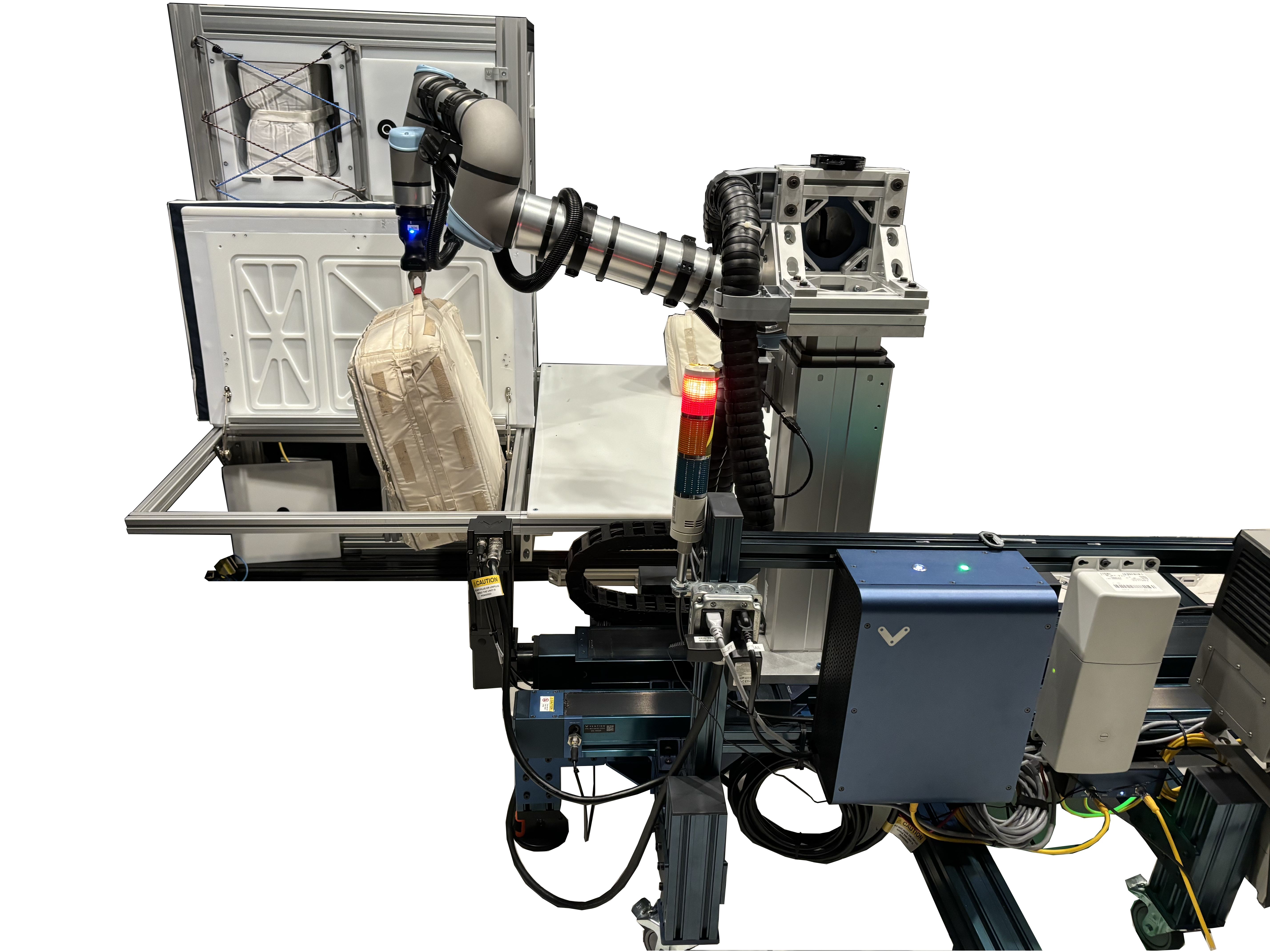
Preparations for Next Moonwalk Simulations Underway (and Underwater) In the Integrated Mobile Evaluation Testbed for Robotics Operations facility at Johnson Space Center, PickNik robotic control software proved its prowess in tasks like passing cargo transfer bags through a hatch and placing them in storage bins, in anticipation of work NASA would like robots to carry out during the later Artemis missions.Credit: NASAAs NASA plans long-term missions on the Moon, the agency could use robots to perform routine tasks, allowing crew members to dedicate more time to science and exploration. However, robotic motion control requires complex technology and advances in features like robotic decision-making and object recognition.
These are the challenges a Boulder, Colorado-based robotics company is teaming up with NASA to overcome.
PickNik Inc. recently worked with Shaun Azimi, who leads the Dexterous Robotics team at NASA’s Johnson Space Center in Houston, and other agency roboticists. The team tested software that enabled a robotic arm to recognize a spacecraft hatch, then turn the latch, grasp the handle, and open the door. The arm then was able to transfer cargo bags between the hatch and a bin.
The work was carried out in NASA Johnson’s new Integrated Mobile Evaluation Testbed for Robotics Operations with funding from NASA’s Small Business Innovation Research program.
PickNik designed and refined the robotic software, called MoveIt Pro, with support from early government investments. Commercially released in 2023, MoveIt Pro has found a significant customer base.
Automotive company BMW is using the software on its robotic assembly lines. A company called Lightspeed is using MoveIt Pro to program huge robotic arms that build modular “panels” for constructing affordable housing. Another company, known as Hivebotics, used MoveIt Pro to automate its flagship product, a cleaning robot.
Ezra Brooks, principal software engineer at PickNik, said the 35-person company might not have a product without NASA’s early support. Robotic software requires years of research and development to refine algorithms and create a commercial product. NASA enabled much of that foundational work.
NASA’s technological advancements unlock key capabilities for missions at the Moon and beyond while benefiting commercial industries on Earth. For 50 years, NASA has documented the everyday benefits of space technology through the agency’s Spinoff publication. To learn more about the project, visit: https://go.nasa.gov/49CNSi7
Read More Share Details Last Updated Jun 10, 2026 Related Terms Explore More 3 min read NASA-Supported Space Tech Advances Earthly Construction Article 4 weeks ago 4 min read Hello Universe: NASA’s Next-Gen Space Processor Undergoes Testing Article 1 month ago 3 min read NASA Heat Shield Technology Enables Space Industry Growth Article 4 months ago Keep Exploring Discover Related TopicsTechnology Transfer & Spinoffs
Artemis
Robotics
Johnson Space Center
Train Ride to NASA Kennedy for Artemis III Booster Segments
The final booster motor segments for NASA’s SLS (Space Launch System) rocket that will help propel Artemis III astronauts on their journey to space shipped from Northrop Grumman’s Railyard Shipping Facility in Corinne, Utah on June 2. The eight booster motor segments are on their way to NASA’s Kennedy Space Center in Florida where they will form the SLS rocket’s twin, five-segment solid rocket boosters, which produce more than 75% of the total thrust at liftoff.
Follow the Artemis blog for updates on Artemis III and future missions.
Image credit: NASA/Brandon Hancock
NASA Webb Finds Strongest Evidence Yet for ‘Black Hole Stars’
- Webb
- News
- Overview
- Science
- Observatory
- Multimedia
- Team
- More
Image: NASA, ESA, CSA, Vasily Kokorev (UT Austin); Image Processing: Alyssa Pagan (STScI)
The complex puzzle known as little red dots has become more complete since their initial discovery by NASA’s James Webb Space Telescope in 2022. Now a particular little red dot’s spectrum is helping connect many of the pieces.
A team of astronomers led by Vasily Kokorev at the University of Texas at Austin identified the lucky dot in question: GLIMPSE-17775. By carefully analyzing the dot’s spectrum captured by Webb — the deepest spectrum to date of a little red dot — the research team has identified multiple lines of evidence, all of which support the interpretation that GLIMPSE-17775 is a supermassive black hole enveloped in a dense cocoon of partially ionized gas, a model referred to as the BH* (black hole star) scenario. A paper describing the results was published today in The Astrophysical Journal.
“I think part of the scientific community is converging on a singular picture — that little red dots can be explained by black hole star models. But none of the previous little red dots have all of the pieces of evidence in the same place,” said Kokorev, lead author of the study. “With GLIMPSE-17775 we can test these models because of how deep and amazing this source’s spectrum is.”
Image: Abell S1063 with Pullout of GLIMPSE-17775 (NIRCam Image) While the primary purpose of NASA’s James Webb Space Telescope’s observations of galaxy cluster Abell S1063 was to look for a certain population of stars, scientists obtained a detailed spectrum of GLIMPSE-17775 from the dataset. This little red dot is located behind Abell S1063. Image: NASA, ESA, CSA, Vasily Kokorev (UT Austin); Image Processing: Alyssa Pagan (STScI) Connecting puzzle piecesSoon after Webb first began science operations, it discovered a new, mysterious type of object in the very early universe – abundant red objects that emerged about 600 million years after the big bang. Scientists have explored multiple explanations for these little red dots, including the black hole star scenario.
A set of fortunate circumstances brought about this new, elaborate spectrum of a little red dot. The little red dot that would come to be known as GLIMPSE-17775 was fortunately included in Webb’s imaging and spectroscopy efforts for a project that sought to look for Population III stars and faint galaxies in galaxy cluster Abell S1063. This little red dot is more distant than the galaxy cluster and magnified by gravitational lensing. (GLIMPSE-17775 has a cosmological redshift of 3.5, meaning it existed about 1.8 billion years after the big bang.)
While Webb provided a 30-hour spectrum of the little red dot, the effect of gravitational lensing made it equivalent to 80 hours of telescope time. This combination of Webb’s infrared sensitivity and nature’s own “magnifying glass” amplified the amount of detail that could be gleaned from GLIMPSE-17775. The result was more than 40 spectral lines from this small, red source, which is the most detailed little red dot spectrum to date.
“When we saw the spectrum for the first time, it was like having all the pieces of a puzzle scattered on the floor,” said Kokorev. “We picked up each piece of the puzzle, measured the lines, and started combining the different pieces into a mosaic. Maybe a few pieces looked like nothing at first, but then a couple of them came together, and we realized that there was something there.”
The spectroscopic data collected by Webb contains multiple lines of evidence that support the interpretation that little red dot GLIMPSE-17775 is a black hole star: a rapidly accreting, or growing, black hole enveloped in a dense gas cocoon, which is reprocessing the light emitted from near the black hole and producing the features seen in the spectrum.
Image: Evidence of a ‘Black Hole Star’ NASA’s James Webb Space Telescope captured the deepest spectrum to date of a little red dot. More than 40 spectral lines have been discerned from the data, many of which independently support the theory that GLIMPSE-17775 is a black hole enshrouded by a hot, dense gas cocoon. Illustration: NASA, ESA, CSA, Vasily Kokorev (UT Austin); Designer: Leah Hustak (STScI) Lines of evidenceAmong the 40-plus lines that the team detected in GLIMPSE-17775’s spectrum were various independent indicators that all align with the BH* scenario. For example, the team found that many of the spectral lines, such as hydrogen, oxygen, and helium, do not fit a simple model of a rotating gas cloud. Instead, the best fit model includes a broadening effect known as electron scattering, a telltale sign that a dense, layered gas cocoon is enshrouding this source.
The strength and ratios of certain lines to each other, most notably the 16 iron lines that compose what the team has dubbed an “iron forest” and certain oxygen lines, require a high-energy source to produce them, like a rapidly accreting black hole. Additionally, astronomers noted the fluorescence and absorption of helium in the spectrum, both of which individually suggest that there is a dense medium enveloping a powerful source.
The BH* scenario not only fits GLIMPSE-17775; it also accounts for why most little red dots are faint in X-rays, since any such emission is likely absorbed by the dense gas cocoon.
One missing element of the GLIMPSE-17775 puzzle piece is the part of the spectrum that would reveal what’s known as a Balmer break, or a strong dip in the emitted light that’s a signature characteristic of little red dots. To build a more comprehensive understanding of this little red dot, the team incorporated ancillary data from two observing programs that used NASA’s Hubble Space Telescope: the Frontier Fields and BUFFALO (Beyond Ultra-deep Frontier Fields And Legacy Observations) programs.
The Webb and Hubble data together help explain why the Balmer break is weaker than what typically is found in other little red dots: A giant host galaxy is surrounding GLIMPSE-17775. Although a little red dot’s host galaxy is not something that has been usually seen at such scale before, it isn’t inconsistent with the dense gas cocoon model. The black hole star model of little red dots attributes excess blue light to stars in the host galaxy.
When Webb first discovered little red dots, some researchers thought these objects had “broken cosmology,” unsure how galaxies could have grown so big so quickly in the early universe to account for all this light coming from their stars. However, the team believes the GLIMPSE-17775 puzzle piece fits nicely in the existing framework of the universe’s evolutionary history, because black hole masses don’t need to be as high in order to explain the broad emission lines.
“Everything fits, nothing is broken, and I think that makes the puzzle that is our universe even better,” said Kokorev. “Looking ahead, I’m eager to dive deeper and learn about what is powering the central engines of little red dots. While we think it’s a black hole, there are some other interesting theories being proposed, which is exciting. Maybe in a year or two, we’ll have the final answer to what powers these sources.”
The James Webb Space Telescope is the world’s premier space science observatory. Webb is solving mysteries in our solar system, looking beyond to distant worlds around other stars, and probing the mysterious structures and origins of our universe and our place in it. Webb is an international program led by NASA with its partners, ESA (European Space Agency) and CSA (Canadian Space Agency).
To learn more about Webb, visit:
Downloads & Related InformationThe following sections contain links to download this article’s images and videos in all available resolutions followed by related information links, media contacts, and if available, research paper and Spanish translation links.
Related Images & Videos Abell S1063 with Pullout of GLIMPSE-17775 (NIRCam Image)While the primary purpose of NASA’s James Webb Space Telescope’s observations of galaxy cluster Abell S1063 was to look for a certain population of stars, scientists obtained a detailed spectrum of GLIMPSE-17775 from the dataset. This little red dot is located behind Abell S1063.
Evidence of a ‘Black Hole Star’
NASA’s James Webb Space Telescope captured the deepest spectrum to date of a little red dot. More than 40 spectral lines have been discerned from the data, many of which independently support the theory that GLIMPSE-17775 is a black hole enshrouded by a hot, dense gas cocoon.
Related Links
Read more: Black Hole Basics
Explore more: ViewSpace | Black Holes: Searching for the unseen
Watch: NASA Black Hole Visualization Takes Viewers Beyond the Brink
Watch: What Webb Learns from Light
Explore more: NASA’s Universe of Learning: Black Hole Resources
Read more: NASA Connects Little Red Dots with Chandra, Webb
Contact Media
Laura Betz
NASA’s Goddard Space Flight Center
Greenbelt, Maryland
laura.e.betz@nasa.gov
Abigail Major
Space Telescope Science Institute
Baltimore, Maryland
Christine Pulliam
Space Telescope Science Institute
Baltimore, Maryland
Related Terms Keep Exploring Related Topics James Webb Space Telescope
Webb is the premier observatory of the next decade, serving thousands of astronomers worldwide. It studies every phase in the…
Black Holes
Stars
Universe
Jim Irons, Former Landsat Project Scientist, Wins Pecora Award
- Landsat Home
- Missions
- News
- Data
- Benefits
- Outreach
- Multimedia
- About
- Search
Last month, Landsat’s very own Jim Irons won the prestigious William T. Pecora Award.
Irons, now an emeritus scientist at NASA Goddard Space Flight Center, played an integral role in shaping the Landsat program into what it is today. He served as deputy project scientist for Landsat 7 before taking over as project scientist for Landsat 8. From the earliest days of Landsat 8—then called the Landsat Data Continuity Mission (LDCM)—all the way through launch and operation, Irons worked across the agency and with colleagues at the USGS to ensure that Landsat continued providing critical data to researchers around the world. He championed rigorous calibration standards and fought to keep the thermal band on Landsat 8. Now, with projects like OpenET relying on evapotranspiration data derived from Landsat thermal imagery, the strength of his vision has only become more apparent.
Irons also served as the director of NASA Goddard’s Earth Science Division during the turbulent early days of the COVID-19 pandemic. Contending with global disruption, he prioritized making sure that everyone had the support that they needed to continue doing great work. As a leader and a scientist, Irons left a legacy of collaboration and innovation that lives on today.
We checked in with Irons about his role in Landsat’s history, what it takes to be a good leader, and winning the Pecora award:
NASA missions are so collaborative. Are there mentors, colleagues, or teams that you would want to share this recognition with or give special mention to?One reason I feel so honored is that prior recipients have been my supervisors, mentors, role models, and colleagues whose work I admired and who inspired me. There’s a long list of people who have been recipients, and I am very honored to be added to that list.
There are also many people who have not yet been recognized who are very deserving. I’ve written letters of support for others, and I hope I’m called on again because there are more people who deserve recognition than there are awards to give out.
One of the things highlighted in the Pecora Award announcement was your commitment to the long-term continuous data record of Landsat. Looking at the Landsat program, why is this continuity so critical for Earth science today?Data continuity is the backbone of the Landsat program. We are looking for change over time. When we talk about climate change and the impact of humans on the land surface, those changes are multi-decadal. We wouldn’t be able to understand, characterize, and monitor those changes without a continuous data record.
And it’s really important that the data record is well-calibrated. When we see changes between data from one Landsat sensor relative to another, we need to be confident that it’s a change occurring on the Earth, not a change in the performance of the sensors.
That’s another major contribution cited in your award: how much you pushed for rigorous data calibration and quality assurance. How did you establish those processes, and how did that make Landsat the gold standard of satellite data?Early in my career, I got in trouble over calibration. NASA was flying an airborne sensor called the Thematic Mapper Simulator, intended to anticipate the capabilities of Landsat 4 and 5. But the operators kept changing the radiometric gain in-flight to maximize the dynamic range. I told NASA Headquarters that we couldn’t compare that data to the actual Thematic Mappers if they kept changing the gain—it wasn’t the same radiometry! The HQ manager got really upset, but I weathered the storm and stuck to my guns.
Later, when Landsat 4 and 5 were returned to the U.S. government from private operation, there had been no real calibration since launch. I advocated for a ground system component at USGS EROS to perform calibration. I didn’t build it, but I did advocate for USGS to hire a brilliant guy named Jim Storey, who developed the software for the precise geolocation of pixels in the data.
When I became Landsat 8 Project Scientist, we needed a pre-launch calibration lead. I advocated for Brian Markham. Brian just did a remarkable job ensuring the calibration of the Operational Land Imager (OLI) and its cross-calibration with previous instruments. He was modest, humble, and built a highly effective team across private industry and agencies.
Another important part of your legacy was the effort to ensure that thermal-infrared measurements continued onto Landsat 8. Why was retaining those measurements so important?Back when USGS charged for data, the use of thermal data was minimal. Some well-respected papers even claimed it wouldn’t be possible to use thermal data to estimate evapotranspiration rates. Based on that, the Director of Earth Sciences at NASA HQ was convinced that the thermal capability wasn’t providing a return on investment.
But while this debate was ongoing, people began developing methodologies for estimating evapotranspiration and water consumption using thermal data—prominently Martha Anderson at the USDA, and researchers at the University of Idaho. It became crucial for monitoring agricultural water use in the West, and was even used in adjudicating water rights. It was also useful for cloud detection and fire monitoring.
I felt strongly that dropping the thermal capability was inconsistent with our directive to continue the Landsat data record. However, due to time pressures and budget constraints, the decision was initially made to fly Landsat 8 without a thermal instrument. But then, when our schedule was pushed back by an independent review board, a window opened up. Center Director Ed Weiler, who had moved to HQ, supported putting a thermal sensor on the payload. Kathy Richardson and engineer Fernando Pellerano were assigned to build it on an incredibly tight schedule, and they did an unbelievable job.
Now, deriving evapotranspiration rates for water consumption is considered essential. Ironically, for Landsat 9, NASA HQ even briefly considered launching a satellite with only a thermal sensor!
You were the Project Scientist from the earliest days of the Landsat Data Continuity Mission (LDCM) all the way through the Landsat 8 launch and beyond. What was the biggest challenge you faced during its development?There were a lot of problems. Laughs. Because of the Land Remote Sensing Policy Act of 1992, the government was exploring commercial data buys for the follow-on mission. NASA spent five painful years attempting to implement LDCM as a commercial data buy. Only one company ultimately responded to the RFP, and it wasn’t a good deal for NASA, so it was rejected.
Then we were directed to put the Landsat sensor on an NPOESS platform (combining civilian and military weather satellite requirements). That platform wasn’t technically suitable, and the program ultimately fell apart.
Finally, the Office of Science and Technology Policy directed us to launch a free-flyer. Bill Ochs took over as project manager, and he deserves so much credit for the success of Landsat 8. He essentially rescued the project and put it on a path to success.
Reflecting on the partnership between USGS and NASA, how did you help build that, and what makes long-term interagency collaboration possible?Darrell Williams and I worked very hard to establish a good relationship between NASA Goddard and USGS EROS. I took many trips to Sioux Falls. With Landsat 7, the EROS Center Director at the time, Don Lauer, brought in new people with great experience, like Jim Storey, Doug Daniels, and Jim Nelson. They developed the geometric rectification software for Landsat 7, and by the time we worked on Landsat 8, they had the right people in place to develop the whole data processing system. And we all got along really well with them. We still keep in touch with a number of them and consider them friends.
With Landsat 10 on the horizon, are there emerging applications or discoveries you’re excited about?Yes. A major emerging capability is using Landsat data in concert with other systems, like ESA’s Sentinel-2, or with LIDAR and radar for 3D forest mapping. The community has asked for more frequent observations, especially more frequent thermal observations to measure water consumption more precisely without extrapolating over long gaps during the growing season.
There’s also great interest in using Landsat for water quality assessment, combining it with the PACE mission to monitor coastal and inland water quality. And tracking glacial velocities, glacial retreat, and even population displacement in conflict regions are all expanding areas. Landsat is truly foundational.
What was your biggest takeaway about leadership from your role as Director for the Earth Science Division at Goddard?I was asked to step up after my predecessor, Piers Sellers—who was an absolute superstar—passed away. My main goal was simply to create an environment where the highly diverse researchers within the division could be successful. I wanted to minimize bureaucratic hindrances so they could focus on their work.
What I learned is that there is a limit to authority. Dictating doesn’t work. You have to lead, engage people, bring them into discussions, and get their buy-in. I used to joke that the job was like working with 1,400 valedictorians! It’s a high-achieving, dedicated group. My challenge was sometimes just reminding them to respect the work of the person down the hall, because people can get so fiercely focused on their own research.
My primary goal during my tenure was to provide stability, especially since it spanned what was then the longest government shutdown in history, followed by the COVID-19 pandemic. I was incredibly impressed by how productive the division remained through a complete disruption in how they worked.
What is the most important piece of advice you would give to young scientists?Persistence. Persistence in pursuing your interests is critical. The only reason Landsat 8 was a success was that we persisted through several failed attempts to reformulate the program, schedule challenges, and budget uncertainties.
Funding and mission success aren’t entitlements based on your name or reputation. You have to work hard, keep putting forward proposals, do good work, and persist through rejections. If you really believe in what you’re doing, Goddard is a great place to work. You can get a lot done. But it takes persistence.
This interview was condensed and lightly edited for clarity.
Explore More
Jim Irons, Former Landsat Project Scientist, Wins Pecora Award
9 min read
Landsat’s Jim Irons won the prestigious William T. Pecora Award. Irons, now an emeritus scientist at NASA Goddard Space Flight Center,…
Jun 10, 2026 ArticleDigging Back in Time in the UAE
5 min read
Once below a shallow sea, Jabal al Fāyah now stands above the desert in the United Arab Emirates as a…
Jun 8, 2026 ArticleFire’s Footprint on Santa Rosa Island
3 min read
A wildland fire charred grassland, coastal sage scrub, and chaparral across one-third of the island, the second largest of the…
Jun 2, 2026 Article1
2
3
…
312
Next