
Feed aggregator
What really happened on Easter Island?
For decades, an influential theory blamed the Rapanui for their own downfall—a story made famous by Jared Diamond’s book Collapse. New evidence tells a different tale
From geothermal energy to tidal power, these bold projects could change our clean-energy future
Companies are making big bets on technology to solve lingering challenges in the clean-energy rollout. Here are four of the most ambitious projects
How NASA turned a spy satellite into the Nancy Grace Roman Space Telescope
NASA’s Nancy Grace Roman Space Telescope will soon launch to unravel the mysteries of dark energy and dark matter
Can QuantumScape and Factorial Energy mass-produce solid-state batteries?
Two American companies are pursuing rival manufacturing strategies for these long-promised cells in an industry China dominates
See gorgeous views of the Aug. 12 total solar eclipse captured from space
The Aug. 12 total solar eclipse didn't only plunge millions of people across Greenland, Iceland and Spain into a false twilight — a fleet of spacecraft orbiting our planet managed to capture the magic, too.
August's total solar eclipse occurred as the moon passed directly between the sun and Earth during its monthly new moon phase. Those lucky enough to be in the path of totality watched on in awe as the moon progressively swallowed the light of the sun, ultimately revealing our star's tenuous atmosphere against a prematurely darkened evening sky.
It was a show of truly epic proportions — and maybe one whose scale can be particularly appreciated when viewed through the mechanical eyes of NASA and European Space Agency (ESA) spacecraft that observe our planet and sun from afar. Read on to see some breathtaking views of the Aug. 12 total solar eclipse from orbit.
The Aug. 12 total solar eclipse, seen from spaceOur first view comes courtesy of NASA astronaut Jessica Meir, who captured the moon taking a bite out of the sun from the Russian segment of the International Space Station (ISS) on Aug. 12.
The partially eclipsed sun as photographed by NASA astronaut Jessica Meir from the Russian segment of the International Space Station on Aug. 12. (Image credit: NASA/Jessica Meir via X)"Given the location of the @Space_Station at the time of the total solar eclipse today, we saw only a partial eclipse, with a peak of around 18% sun coverage," Meir said in an X post accompanying the photographs.
Given the location of the @Space_Station at the time of the total solar eclipse today, we saw only a partial eclipse, with a peak of around 18% sun coverage. Here’s how it looked from a window in the Russian segment about 45 minutes ago. Photo of the sun taken with a Nikon Z9,… pic.twitter.com/BUrMQVR808August 12, 2026
Around the same time, photographer Joel Kowsky managed to line up a beautiful shot of the ISS as it passed across the face of our eclipsed star in the skies over Hodgdon, Maine.
This gif shows the ISS' silhouette moving across the sun's face during a partial solar eclipse on Aug. 12, 2026. (Image credit: NASA/Joel Kowsky)The dual spacecraft of the European Space Agency's Proba-3 mission also captured a lovely (though largely redundant) view of the moon moving to occult the sun's disk, which, in this case, was already perfectly hidden behind the lead spacecraft's coronograph!
Both Proba-3 spacecraft are designed to fly in perfect formation in line with the sun. The "Occulter" spacecraft, closest to the sun, is equipped with a large sunshield, or coronagraph. This coronagraph blocks the sun's disk for the more distant member in the Proba-3 formation, allowing that spacecraft to image our star's atmosphere in incredible detail.
The sun's disk is pictured hidden behind the coronograph of the lead Proba-3 spacecraft with the moon's silhouette above, just hours before the Aug. 12 total solar eclipse. (Image credit: ESA/Proba-3/ASPIICS under CC BY-SA 3.0 IGO, alterations made in Canva by Anthony Wood.)Thanks to their unique setup, for a brief moment on Aug. 12, the Proba-3 spacecraft recorded a rare double eclipse, as the moon and its artificial mimic simultaneously hid light emanating from our parent star.
Sitting about 22,370 miles (36,000 kilometers) above Earth's surface, ESA's Meteosat Third Generation Imager Satellite (MGT-I1) caught a spectacular view of the moon's shadow darkening our planet.
Solar eclipse as seen from space! From its vantage point in space, the Meteosat Third Generation Imager satellite (MTG-I1) captured the Moon’s dark shadow as it passed over Earth’s surface – converging with the advancing twilight shadow as dusk fell over Europe.… pic.twitter.com/dAQVyuXiIPAugust 13, 2026
The moon's shadow can be seen arcing south in the satellite imagery, before eventually combining with the advancing terminator line, which heralded the transition from day to night wherever it passed.
That same shadow was observed on Aug. 12 by the U.S. National Oceanic and Atmospheric Administration's GOES-19 satellite as it kept watch over Earth from its perch in geostationary orbit.
This #FullDiskFriday, we revisit the #totalsolareclipse that @NOAA’s #GOESEast (#GOES19)
APOD: 2026 August 18 – Perseids from Perseus
APOD
Astronomy Picture of the Day
Discover the cosmos! Each day a different image or photograph of our fascinating universe is featured, along with a brief explanation written by a professional astronomer.
Perseids from Perseus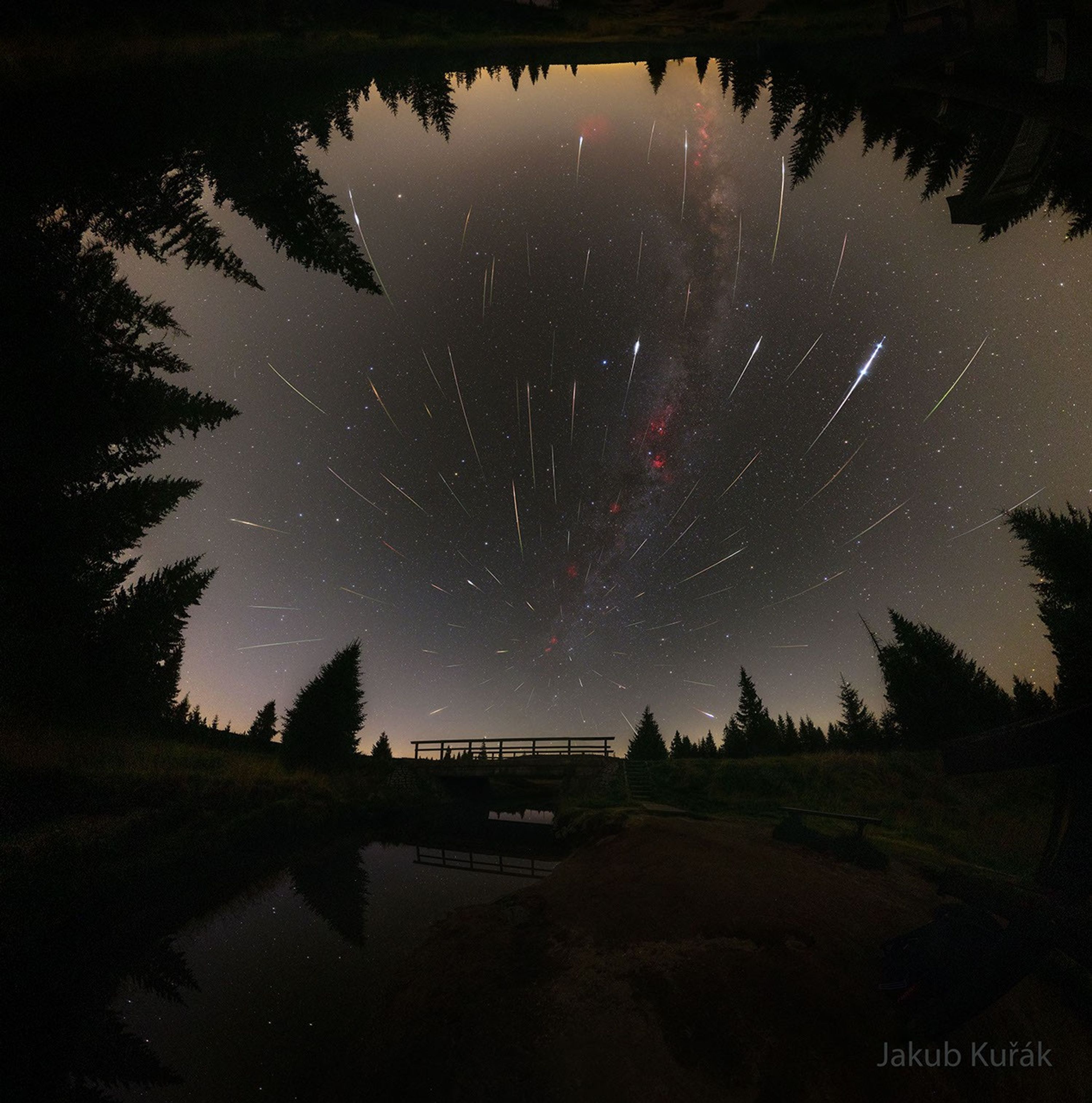
Explanation: This was a good year for the Perseids meteor shower. A key reason was the Moon was absent from lighting up Earth’s night sky so that more meteors were visible than usual. Where was the Moon? It was busy visiting the Sun. Near the Perseids peak, the Moon moved directly in front of the Sun and created a total solar eclipse visible from Greenland and Spain. The Perseids occur when the Earth collides with a stream of Sun-orbiting debris cast off by Comet Swift-Tuttle. Perseid meteors, although typically only the size of a sand grain, tend to be fast and bright because Swift-Tuttle’s debris orbits the Sun in a direction partly opposite Earth’s orbital motion. In the featured image compilation, accumulated over several nights from Jizerka in the Czech Republic, the Perseids meteor streaks can be traced back to a single location on the sky — its radiant in Perseus.
Gallery: Perseids Meteor Shower of 2026
Tomorrow’s picture: open space

NASA Science Activation & Michigan Tech. U. Random APOD Generator Yesterday’s Image APOD: 2026 August 17 – A Golden Corona Eclipse Tomorrow’s Image
APOD: 2026 August 18 – Perseids from Perseus
APOD
Astronomy Picture of the Day
Discover the cosmos! Each day a different image or photograph of our fascinating universe is featured, along with a brief explanation written by a professional astronomer.
Perseids from Perseus
Explanation: This was a good year for the Perseids meteor shower. A key reason was the Moon was absent from lighting up Earth’s night sky so that more meteors were visible than usual. Where was the Moon? It was busy visiting the Sun. Near the Perseids peak, the Moon moved directly in front of the Sun and created a total solar eclipse visible from Greenland and Spain. The Perseids occur when the Earth collides with a stream of Sun-orbiting debris cast off by Comet Swift-Tuttle. Perseid meteors, although typically only the size of a sand grain, tend to be fast and bright because Swift-Tuttle’s debris orbits the Sun in a direction partly opposite Earth’s orbital motion. In the featured image compilation, accumulated over several nights from Jizerka in the Czech Republic, the Perseids meteor streaks can be traced back to a single location on the sky — its radiant in Perseus.
Gallery: Perseids Meteor Shower of 2026
Tomorrow’s picture: open space
NASA Science Activation & Michigan Tech. U. Random APOD Generator Yesterday’s Image APOD: 2026 August 17 – A Golden Corona Eclipse Tomorrow’s Image
Watch European astronaut make history during spacewalk today
Sophie Adenot will make spaceflight history today (Aug. 18).
The European Space Agency (ESA) astronaut will become the first French woman ever to conduct a spacewalk, an activity she'll undertake with NASA astronaut Anil Menon.
The duo are scheduled to step outside the International Space Station (ISS) for a 6.5-hour excursion today at around 8:35 a.m. EDT (1235 GMT). You can watch it live here at Space.com, courtesy of NASA. Coverage starts at 7 a.m. EDT (1100 GMT).
Sophie Adenot is part of the European Space Agency's 2022 astronaut class. (Image credit: ESA)Adenot and Menon will "replace a space-to-ground antenna on the orbital complex," NASA officials wrote in a spacewalk preview.
"The antenna is a critical communications link NASA uses to transmit data, enabling high-speed communications between the Mission Control Center in Houston and the space station," they added.
This will be the second spacewalk for Menon; his first one, conducted with fellow NASA astronaut Jessica Meir, occurred on Aug. 6. During that extravehicular activity (EVA), a carbon dioxide sensor on Menon's spacesuit gave "an unexpected data reading," NASA officials wrote in an Aug. 7 update.
The sensor returned to normal after Menon doffed the suit, but NASA took some extra time to make sure there was no serious issue. As a result, the agency pushed his second spacewalk back a few days — from the originally planned Aug. 13 to today.
Today's spacewalk will be the 282nd overall in the long history of the ISS. Menon, who reached orbit on a Russian Soyuz spacecraft on July 14, will be "crewmember 1" on the EVA. Adenot — a member of SpaceX's Crew-12 mission, which reached the orbiting lab in February — will be "crewmember 2."
Adenot won't be the first French person overall to conduct an EVA. That distinction goes to Jean-Loup Chrétien, who performed a spacewalk outside the then-Soviet Union's Mir space station in 1988.
Other male French astronauts, including Philippe Perrin and Thomas Pesquet, later spacewalked outside the ISS. Pesquet also became the first French person to command an ISS mission, taking the reins in October 2021.
Lala Batters Hawaii
- Earth
- Earth Observatory
- Image of the Day
- EO Explorer
- Topics
- More Content
- About
Lala Batters Hawaii
- Earth
- Earth Observatory
- Image of the Day
- EO Explorer
- Topics
- More Content
- About
Mars Curiosity Rover Discovers Massive Field of Polygons
The surface of Mars is home to some of the most breathtaking and awe-inspiring landscapes in the solar system. This is primarily due to the Red Planet lacking several re-surfacing processes that Earth possesses, including plate tectonics, volcanism, and flowing water. While Mars does have dust storms, this has done little to reshape the planet’s surface, which has remained largely undisturbed for billions of years. However, this near-pristine landscape has enabled scientists to look back in time while slowly piecing together what Mars was like long ago.
MOTHRA Shows Us A Star Being Recycled in the Helix Nebula
Astronomers used new MOTHRA telescope in Chile to image the famous Helix Nebula. They found 22 glowing shock waves where stellar debris from a dying star collided with interstellar gas. After colliding with gas, stellar fragments remain intact for just 10,000 years, the team estimates. The observations show how dying stars are recycled and return material to the interstellar medium to form new stars and planets.
Curiosity Blog, Sols 4975-4981: Happy 14th Landing Anniversary
- Curiosity Home
- Science
- News and Features
- Multimedia
- Mars Missions
- Mars Home
6 min read
Curiosity Blog, Sols 4975-4981: Happy 14th Landing Anniversary NASA’s Mars rover Curiosity acquired this image, of its onboard APXS instrument measuring target “Tunas Khasa,” using its Front Hazard Avoidance Camera (Front Hazcam). Curiosity captured the image on Sol 4976 — Martian day 4,976 of the Mars Science Laboratory mission — at 03:01:56 UTC.NASA/JPL-Caltech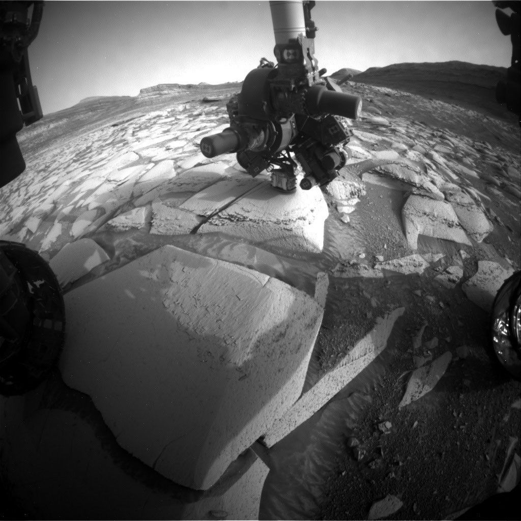
By Susanne P. Schwenzer, Professor of Planetary Mineralogy at The Open University, UK
Earth planning date: Friday, Aug. 7, 2026
This week was very special for the Curiosity team here on Earth as we celebrated the 14th landing anniversary. I still remember watching the buildup to the entry phase on “Eyes on the Solar System” and then I don’t remember much until I heard the words, “We are safe on Mars.” I was just too tense and nervous, but I love to re-live the moments each year when we celebrate another (Earth) year on Mars. If you want to remember it all, you can go to NASA’s interactive tool “Eyes on the Solar System” use the menu and find the Mars Science Laboratory Rover in the list of spacecraft. Curiosity launched Nov. 26, 2011, 15:02 UTC; you can wind back the clock to that day as the spacecraft leaves Earth and follow as it gradually makes its way to Martian orbit, where it meets Mars at just the right moment. Curiosity landed Aug. 6, 2012, 05:17 UTC. The big moment to me, though, is to see the joy and celebrations in the control room after landing. I have watched this video more times than I can count; it’s just too good to not remember: Curiosity Has Landed – NASA Science.
But what did we do in that very special week that marked the transition from year 14 to year 15? Of course it was business as usual for the rover while many of us exchanged memories and also marveled at what we have found to date. If you are interested what exactly Curiosity did at the moment in time that marked the landing anniversary, we’ve got you covered — with the help of the science and engineering team at JPL in Pasadena, I can tell you that this was on Sol 4976 at 19:47 LMST on Mars, and at that very moment the rover’s arm was deployed at the target “Tunas Khasa” doing an APXS measurement.
The rover continued its way up Mount Sharp investigating the different layers of rock along the way. This climb can be quite steep and coming into Monday’s plan was no different. At one point last Friday the rover’s tilt was 24 degrees. But the engineers know exactly what Curiosity can do, so we arrived safely at our planned location coming into Monday. At this first stop of the week, the APXS measured “Tunas Khasa” and “Villarrica,” which were also imaged with our Mars Hand Lens Imager (MAHLI). More chemistry came from ChemCam investigating the targets “Lago Rupanco” and “Chulipa Punta.” ChemCam also used its Remote Micro Imager to acquire high-resolution images of targets of interest. We are specifically looking for the cross-bedding, a term geologists use to describe rock layers that tilt and intersect each other, and how the different layers of rock relate to each other. Mastcam had five different mosaics in the plan, investigating targets in the nearfield and looking into the distance, too. The targets range from layers of rocks in the walls that make up the buttes around the rover to bedrock targets in the nearfield. “La Linea” is a surface that displays signs of erosion, and “Tiraque” gives insights into the layering of the bedrock, just to name two of the Mastcam targets. Of course, the future drive direction and the future workspace were also imaged after the drive. In addition to the science, there were some “housekeeping” activities in the plan, too. Those were a SAM column-cleaning activity and MAHLI images of the REM UV sensor. It’s important to keep on top of these things, too!
The 46-foot (14-meter) drive put us into the perfect position in front of one of those very special places, where not only two different rock layers meet, but also where cross-bedded rocks are truncated by other layers. It is those special places that allow us – one by one – to put the pieces of the puzzle together, showing what happened here billions of years ago. One thing is clear: it involved wind, lots of wind, but also some water. As this location is an exceptionally interesting place, we will stay here through Monday and spend two planning cycles at this location.
On Friday we planned two APXS on a bedrock block in front of us – keeping in mind two others for our colleagues to plan on Monday. The two targets are “Salar de Gorbea” and “Uriondo.” MAHLI documents those two, but also has a mosaic in the plan that is one of the largest I have ever seen. It’s on the target “Tres Morros,” which is an excellent example on how exactly those different rock layers meet. The team can’t wait to see the high-resolution MAHLI images and inspect every single detail visible in them. Mastcam also was very busy, investigating representative outcrops in the nearfield and further away. Targets to especially look out for are “Laguna Del Eulogio” and “Laguna de Pozuelo,” as they image outcrops related to the changes in the rock layers and further ahead on a butte called Mishe Mokwa. You might remember the latter from many mentions previously as we were driving along and around it, and using repeated images to get stereo views, but also understand different aspects of the stratigraphy (the way rocks are layered). ChemCam looks at target “Rio Tranquilo,” which is a nodular target, possibly giving insights into the water-related part of the environments that formed those rocks. The other ChemCam target is “Rio Juncalito,” which is a cross-bedded target. ChemCam also has two RMIs in the plan, one targeting forward toward Valle Grande and the other looking at Mishe Mokwa.
Both plans contain a rich set of environmental monitoring. There are many dust-devil surveys alongside measurements of the atmospheric opacity and wind monitoring. We are also looking for clouds, and of course the RAD instrument is actively measuring the radiation environment. It rarely gets a mention here, because it sits quietly in its place within the rover, looking out to the sky and monitoring the radiation — for all those 14 years, and in fact a little longer, because it was the first instrument to be switched on after launch and already started its monitoring during the cruise phase to Mars.
Happy 14th Landing Anniversary, Curiosity!
-
Want to read more posts from the Curiosity team?
-
Want to learn more about Curiosity’s science instruments?
Mars is the fourth planet from the Sun, and the seventh largest. It’s the only planet we know of inhabited…
All Mars ResourcesExplore this collection of Mars images, videos, resources, PDFs, and toolkits. Discover valuable content designed to inform, educate, and inspire,…
Rover BasicsEach robotic explorer sent to the Red Planet has its own unique capabilities driven by science. Many attributes of a…
Mars Exploration: Science GoalsThe key to understanding the past, present or future potential for life on Mars can be found in NASA’s four…
Curiosity Blog, Sols 4975-4981: Happy 14th Landing Anniversary
- Curiosity Home
- Science
- News and Features
- Multimedia
- Mars Missions
- Mars Home
6 min read
Curiosity Blog, Sols 4975-4981: Happy 14th Landing Anniversary NASA’s Mars rover Curiosity acquired this image, of its onboard APXS instrument measuring target “Tunas Khasa,” using its Front Hazard Avoidance Camera (Front Hazcam). Curiosity captured the image on Sol 4976 — Martian day 4,976 of the Mars Science Laboratory mission — at 03:01:56 UTC.NASA/JPL-CaltechBy Susanne P. Schwenzer, Professor of Planetary Mineralogy at The Open University, UK
Earth planning date: Friday, Aug. 7, 2026
This week was very special for the Curiosity team here on Earth as we celebrated the 14th landing anniversary. I still remember watching the buildup to the entry phase on “Eyes on the Solar System” and then I don’t remember much until I heard the words, “We are safe on Mars.” I was just too tense and nervous, but I love to re-live the moments each year when we celebrate another (Earth) year on Mars. If you want to remember it all, you can go to NASA’s interactive tool “Eyes on the Solar System” use the menu and find the Mars Science Laboratory Rover in the list of spacecraft. Curiosity launched Nov. 26, 2011, 15:02 UTC; you can wind back the clock to that day as the spacecraft leaves Earth and follow as it gradually makes its way to Martian orbit, where it meets Mars at just the right moment. Curiosity landed Aug. 6, 2012, 05:17 UTC. The big moment to me, though, is to see the joy and celebrations in the control room after landing. I have watched this video more times than I can count; it’s just too good to not remember: Curiosity Has Landed – NASA Science.
But what did we do in that very special week that marked the transition from year 14 to year 15? Of course it was business as usual for the rover while many of us exchanged memories and also marveled at what we have found to date. If you are interested what exactly Curiosity did at the moment in time that marked the landing anniversary, we’ve got you covered — with the help of the science and engineering team at JPL in Pasadena, I can tell you that this was on Sol 4976 at 19:47 LMST on Mars, and at that very moment the rover’s arm was deployed at the target “Tunas Khasa” doing an APXS measurement.
The rover continued its way up Mount Sharp investigating the different layers of rock along the way. This climb can be quite steep and coming into Monday’s plan was no different. At one point last Friday the rover’s tilt was 24 degrees. But the engineers know exactly what Curiosity can do, so we arrived safely at our planned location coming into Monday. At this first stop of the week, the APXS measured “Tunas Khasa” and “Villarrica,” which were also imaged with our Mars Hand Lens Imager (MAHLI). More chemistry came from ChemCam investigating the targets “Lago Rupanco” and “Chulipa Punta.” ChemCam also used its Remote Micro Imager to acquire high-resolution images of targets of interest. We are specifically looking for the cross-bedding, a term geologists use to describe rock layers that tilt and intersect each other, and how the different layers of rock relate to each other. Mastcam had five different mosaics in the plan, investigating targets in the nearfield and looking into the distance, too. The targets range from layers of rocks in the walls that make up the buttes around the rover to bedrock targets in the nearfield. “La Linea” is a surface that displays signs of erosion, and “Tiraque” gives insights into the layering of the bedrock, just to name two of the Mastcam targets. Of course, the future drive direction and the future workspace were also imaged after the drive. In addition to the science, there were some “housekeeping” activities in the plan, too. Those were a SAM column-cleaning activity and MAHLI images of the REM UV sensor. It’s important to keep on top of these things, too!
The 46-foot (14-meter) drive put us into the perfect position in front of one of those very special places, where not only two different rock layers meet, but also where cross-bedded rocks are truncated by other layers. It is those special places that allow us – one by one – to put the pieces of the puzzle together, showing what happened here billions of years ago. One thing is clear: it involved wind, lots of wind, but also some water. As this location is an exceptionally interesting place, we will stay here through Monday and spend two planning cycles at this location.
On Friday we planned two APXS on a bedrock block in front of us – keeping in mind two others for our colleagues to plan on Monday. The two targets are “Salar de Gorbea” and “Uriondo.” MAHLI documents those two, but also has a mosaic in the plan that is one of the largest I have ever seen. It’s on the target “Tres Morros,” which is an excellent example on how exactly those different rock layers meet. The team can’t wait to see the high-resolution MAHLI images and inspect every single detail visible in them. Mastcam also was very busy, investigating representative outcrops in the nearfield and further away. Targets to especially look out for are “Laguna Del Eulogio” and “Laguna de Pozuelo,” as they image outcrops related to the changes in the rock layers and further ahead on a butte called Mishe Mokwa. You might remember the latter from many mentions previously as we were driving along and around it, and using repeated images to get stereo views, but also understand different aspects of the stratigraphy (the way rocks are layered). ChemCam looks at target “Rio Tranquilo,” which is a nodular target, possibly giving insights into the water-related part of the environments that formed those rocks. The other ChemCam target is “Rio Juncalito,” which is a cross-bedded target. ChemCam also has two RMIs in the plan, one targeting forward toward Valle Grande and the other looking at Mishe Mokwa.
Both plans contain a rich set of environmental monitoring. There are many dust-devil surveys alongside measurements of the atmospheric opacity and wind monitoring. We are also looking for clouds, and of course the RAD instrument is actively measuring the radiation environment. It rarely gets a mention here, because it sits quietly in its place within the rover, looking out to the sky and monitoring the radiation — for all those 14 years, and in fact a little longer, because it was the first instrument to be switched on after launch and already started its monitoring during the cruise phase to Mars.
Happy 14th Landing Anniversary, Curiosity!
-
Want to read more posts from the Curiosity team?
-
Want to learn more about Curiosity’s science instruments?
Mars is the fourth planet from the Sun, and the seventh largest. It’s the only planet we know of inhabited…
All Mars ResourcesExplore this collection of Mars images, videos, resources, PDFs, and toolkits. Discover valuable content designed to inform, educate, and inspire,…
Rover BasicsEach robotic explorer sent to the Red Planet has its own unique capabilities driven by science. Many attributes of a…
Mars Exploration: Science GoalsThe key to understanding the past, present or future potential for life on Mars can be found in NASA’s four…
Webb Captures Clearest Image Yet of the Lion Nebula
The NASA/ESA/CSA James Webb Space Telescope has captured images of NGC 2392 (also known as the Lion Nebula), which Hubble previously imaged in 2000.
Massive Exoplanets Could Form Around Supermassive Black Holes
Black holes aren't just engines of inexorable destruction. They're complex regions of space and time, and under the right conditions, giant planets can form in their AGN disks.
NASA's SkyFall Mars Helicopters Will Feature a Revolutionary Antenna Design
Engineers developed a unique fabric-based design for a ground-penetrating radar that will be a key instrument on NASA’s SkyFall Mars helicopters. The hardware will enable the SkyFall mission’s trio of planetary rotorcraft to use ground-penetrating radar to study the Martian subsurface.