
Feed aggregator
Chance of Aurora Extends to Friday Night, June 5th
A geomagnetic storm expected June 4th arrived late. But there's still at chance of seeing auroras Friday night, June 5th.
The post Chance of Aurora Extends to Friday Night, June 5th appeared first on Sky & Telescope.
New Cloud-Detecting Method Will Help Astronomers Characterize Exoplanets
Astronomers have developed a technique that allows them to detect cloud cycles on distant exoplanets. Using data from the James Webb Sapce Telescope (JWST), the astronomers found that mornings and evenings on the gas giant WASP-94A b have extremely different weather patterns: mornings are riddled with sand clouds, while the skies are clear in the early evenings. By isolating the clouds, researchers can more accurately measure a planet’s atmosphere and provide a clearer picture of the planet’s composition. WASP-94A b, for example, has much less oxygen and carbon than astronomers perviously calculated, making its atmosphere much more like Jupiter than they had originally thought.
Trump invokes Defense Production Act to keep U.S. coal plants running
Coal is the most significant fossil fuel contributor to climate change
NASA Hosts 2026 Review on Advanced Composite Manufacturing
2 min read
Preparations for Next Moonwalk Simulations Underway (and Underwater) Boeing assembles a composite aircraft fuselage section in one of its production facilities. Composite materials are used in major portions of modern aircraft, including sections of the fuselage and wings on aircraft such as the Boeing 787. NASA’s HiCAM project aims to help accelerate manufacturing processes for future composite aircraft. Boeing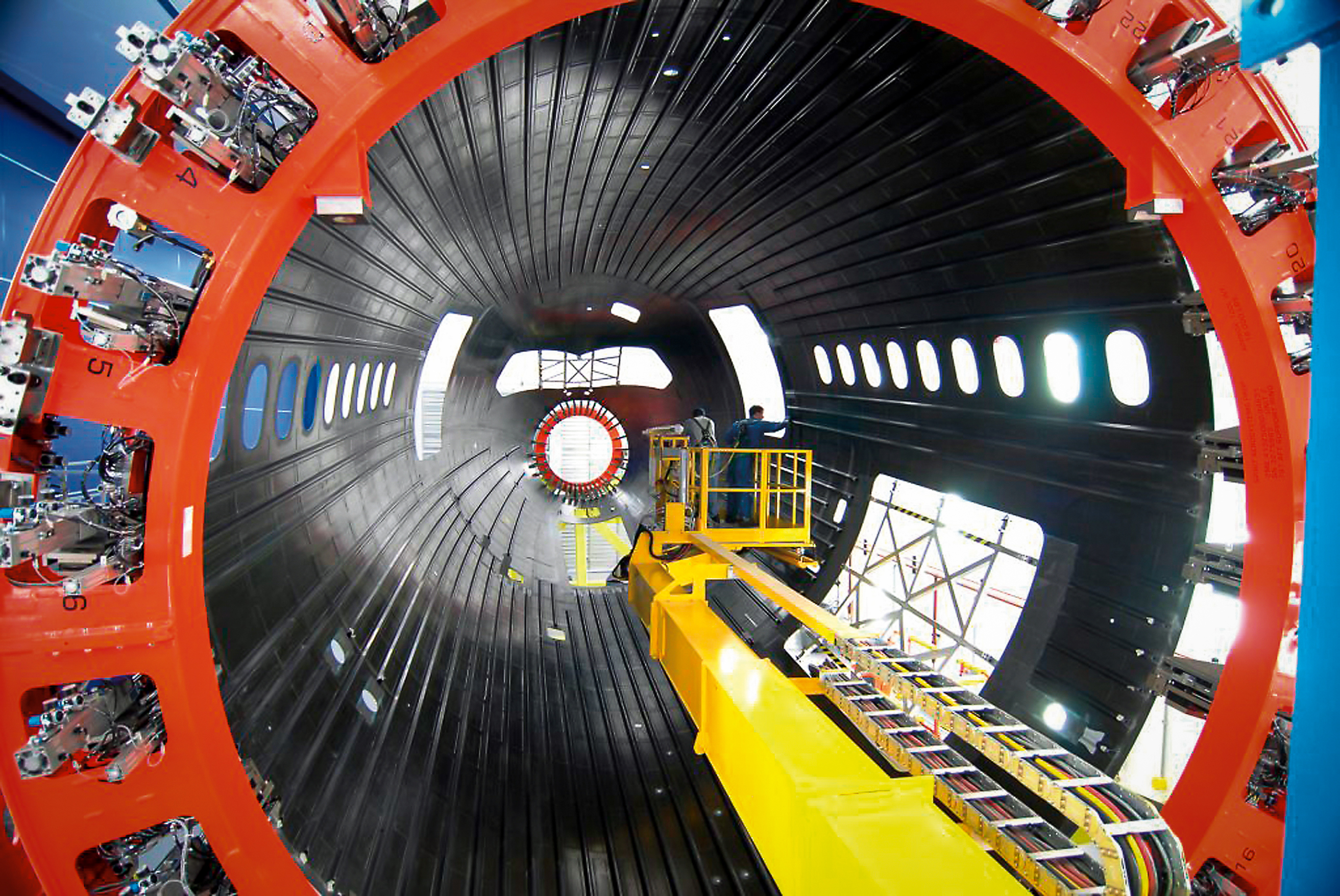
NASA’s Hi-Rate Composite Aircraft Manufacturing (HiCAM) project brought together its full team of Advanced Composites Consortium partners for a 2026 spring review at NASA’s Langley Research Center in Hampton, Virginia.
The meeting took place May 5-7, bringing together about 150 people from the consortium, a 22-member public-private partnership.
The review gave NASA and industry partners a chance to look at recent progress and plan for the work ahead. NASA announced recent portfolio decisions, selecting technologies that can have the greatest impact on manufacturing rate for the next airplane program.
During the meeting, teams reviewed the latest results from the project’s Development Phase and discussed early progress under Phase 2, known as the Demonstration Phase. This phase will scale up key manufacturing technologies in the coming years.
A major part of the event included full-day workshops focused on assembly demonstrations of two large aircraft structures: the wing and fuselage. These sessions brought together NASA researchers, industry engineers, and partners to share updates, exchange ideas, and discuss long-term plans. Many teams said they noticed stronger collaboration and coordination across the group this year.
That collaboration supports HiCAM’s goal of large-scale manufacturing demonstrations of a composite fuselage barrel and wing box in 2028 and 2029. These demonstrations represent major project milestones and will help show how advanced composite materials and processes could support faster, lower cost aircraft production.
NASA and its partners continue to make steady progress toward the project’s goals. The project’s work could help pave the way for new manufacturing methods for lightweight composite structures that make future aircraft easier to build and more efficient to operate.
Kimiko Booker
NASA Langley Research Center
NASA Hosts 2026 Review on Advanced Composite Manufacturing
2 min read
Preparations for Next Moonwalk Simulations Underway (and Underwater) Boeing assembles a composite aircraft fuselage section in one of its production facilities. Composite materials are used in major portions of modern aircraft, including sections of the fuselage and wings on aircraft such as the Boeing 787. NASA’s HiCAM project aims to help accelerate manufacturing processes for future composite aircraft. BoeingNASA’s Hi-Rate Composite Aircraft Manufacturing (HiCAM) project brought together its full team of Advanced Composites Consortium partners for a 2026 spring review at NASA’s Langley Research Center in Hampton, Virginia.
The meeting took place May 5-7, bringing together about 150 people from the consortium, a 22-member public-private partnership.
The review gave NASA and industry partners a chance to look at recent progress and plan for the work ahead. NASA announced recent portfolio decisions, selecting technologies that can have the greatest impact on manufacturing rate for the next airplane program.
During the meeting, teams reviewed the latest results from the project’s Development Phase and discussed early progress under Phase 2, known as the Demonstration Phase. This phase will scale up key manufacturing technologies in the coming years.
A major part of the event included full-day workshops focused on assembly demonstrations of two large aircraft structures: the wing and fuselage. These sessions brought together NASA researchers, industry engineers, and partners to share updates, exchange ideas, and discuss long-term plans. Many teams said they noticed stronger collaboration and coordination across the group this year.
That collaboration supports HiCAM’s goal of large-scale manufacturing demonstrations of a composite fuselage barrel and wing box in 2028 and 2029. These demonstrations represent major project milestones and will help show how advanced composite materials and processes could support faster, lower cost aircraft production.
NASA and its partners continue to make steady progress toward the project’s goals. The project’s work could help pave the way for new manufacturing methods for lightweight composite structures that make future aircraft easier to build and more efficient to operate.
Kimiko Booker
NASA Langley Research Center
Even Without A Magnetosphere, Mars Can Still Deflect Some Solar Wind
New research shows how unmagnetized worlds like Mars can still deflect some of the Sun's solar wind. Unlike magnetospheres that form around planet's like Earth, this effect takes place in Mars' ionosphere. It's called the Zwan-Wolf effect, and it's not clear how deep into the atmosphere it operates.
Remote work is making Americans lonelier and sadder, new study suggests
Remote and hybrid work can have benefits, but a study involving more than 588,000 people suggest they may take a serious mental toll
NASA-Funded Study Shows Wildfire Smoke’s Hidden Ozone Toll
- Earth
- Explore
- Science at Work
- Multimedia
- Data
- For Researchers
- About Us
NASA’s Goddard Space Flight Center
Wildfire smoke is stoking a new challenge for cleaner air. A NASA-supported study published Thursday found that, over the last decade, wildfires have worsened ground-level ozone pollution across much of the contiguous United States, creating unhealthy air far from active flames.
Wildfires have become an increasingly important contributor to ground-level ozone, or smog, across much of the United States, researchers report June 4 in the journal Science. Nationally, fires offset nearly four years’ worth of ozone-control gains, with larger setbacks in the West and Midwest.
Smoke often is associated with the soot, ash, and other fine particles that make the air look hazy. But wildfires also emit gases such as carbon monoxide, which can help form surface ozone in sunlight when other pollutants are present. Surface ozone is an invisible pollutant harmful to human health, plants, and crops. As smoke plumes travel and mix with other pollution, those reactions can drive ozone increases hundreds or even thousands of miles from active fires.
“NASA Earth observations, along with ground monitoring networks, help reveal air quality risks from wildfires that can cross state lines, giving air quality managers better decision-making information as wildfire smoke affects more communities,” said John Haynes, manager of NASA Earth Action’s Health and Air Quality program at the agency’s Headquarters in Washington. “This is a strong example of NASA science serving communities here in the U.S.”
Building a clearer ozone pictureHigh in the atmosphere, ozone shields Earth from harmful ultraviolet radiation. Near the ground, however, ozone can irritate lungs, worsen asthma and other respiratory diseases, and increase health risks for children, older adults, outdoor workers, and people with existing health conditions.
To track surface ozone changes, researchers turned to deep learning, a form of artificial intelligence that finds patterns across large datasets. They used it to build a first-of-its-kind dataset estimating daily surface ozone from 2003 to 2024 on a kilometer-by-kilometer grid — about 0.6 miles on each side — across the contiguous U.S. The work received support from NASA’s Health and Air Quality program and other NASA grants.
The scientists combined data from about 1,000 ground-based air quality stations with atmospheric model data, weather information, wildfire pollution data, and satellite-derived information, including products from the Visible Infrared Imaging Radiometer Suite (VIIRS) and the Moderate Resolution Imaging Spectroradiometer (MODIS) instruments.
Smoke from Canada’s 2023 wildfires spread across North America. Tan to deep red colors show smoke intensity, estimated from black carbon in NASA’s GEOS-FP model. NASA’s Scientific Visualization Studio (SVS) and NASA’s Global Modeling Assimilation Office (GMAO)Their analysis revealed two distinct periods. From 2003 to 2015, U.S. ground-level ozone generally declined as emissions of ozone-forming pollutants decreased. After 2015, however, those gains slowed or reversed in many places. By comparing estimated ozone levels with scenarios that removed wildfire influence, the researchers found that pollution from wildfires was a main factor in that shift.
Without the wildfire contribution, ground-level ozone in the Midwest, for example, would likely have continued to decline. Instead, wildfires erased about 5.3 years’ worth of ozone-control progress since 2015.
“People in the Midwest may think fires burning far away will not affect them,” said the study’s corresponding author Jun Wang, an atmospheric scientist at the University of Iowa in Iowa City. “But once wildfire pollution is in the air, it can move across regions. Pollution from one place can affect air quality in another.”
Measuring the health tollThe study also found that wildfire-driven ozone increased exposure to unhealthy air and likely contributed to premature deaths. Premature deaths associated with long-term wildfire-related ozone exposure in the U.S. increased by an estimated 318 deaths per year after 2013, with the post-2013 average 46% higher than in the previous decade. The researchers calculated premature deaths using average lifespan, ozone exposure estimates, and population density.
The 2023 Canadian wildfires showed how widely those risks can spread, with smoke-driven ozone increases stretching across the Midwest and into parts of the Northeast and South. Overall, from 2022 to 2024, wildfires exposed an additional 43 million people in the U.S. to conditions that did not meet current federal air quality standards for ozone, the researchers estimated.
Capturing that national picture is difficult from ground monitors alone. Ground monitors remain the backbone of U.S. air quality tracking, but they do not cover every community. NASA’s scientifically validated satellite observations and models help researchers and agencies see air quality patterns across states, regions, and fire seasons.
That broader air quality work includes newer missions such as TEMPO (Tropospheric Emissions: Monitoring of Pollution). Launched in 2023, TEMPO is NASA’s first mission to use a space-based spectrometer to provide hourly daytime measurements of air quality over North America. Its view is sharp enough to distinguish pollution patterns, including surface ozone, across areas only a few square miles wide, a major improvement over earlier satellites.
Together, these capabilities help researchers and agencies see smoke-related ozone patterns that might otherwise be harder to detect, especially in rural and remote areas.
The work also points toward a practical use of NASA science during fire season. Wang’s team has used NASA support to develop FireAQ, a decision-support system that brings satellite observations, model forecasts, and fire and aerosol products into weekly briefings with state and local air quality officials. The goal is to help officials see where smoke-related pollution may move next and give communities better information.
Discover more about NASA’s air quality observations
About the Author Emily DeMarco Writer/Editor (IV), Earth Science Division
Share
Details Last Updated Jun 05, 2026 Contact Emily DeMarco emily.p.demarco@nasa.gov Location Goddard Space Flight Center Related Terms Explore More 3 min read Fighting Fire With FireIn fire-prone ecosystems in Australia’s Northern Territory, prescribed burns are lit to minimize the severity…
Article
16 hours ago
4 min read A Moonlit Earth as Seen From Artemis II
An astronaut’s photo, taken en route to the Moon, reveals our planet and its place…
Article
2 days ago
2 min read Typhoon Jangmi
The sprawling storm promised to deliver torrential rain across a wide swath of southern Japan.
Article
3 days ago
Keep Exploring Discover More Topics From NASA Air Quality
Air pollution is a significant threat to human health and our environment. Instruments on NASA satellites, along with airborne and…
Wildfires
Landsat satellites monitor wildfire extent, burn severity, and post-fire recovery since the 1970s, helping managers assess damage, improve safety, estimate…
Earth Science at Work
NASA Earth Science helps Americans respond to challenges and societal needs — such as wildland fires, hurricanes, and water supplies…
NASA Knows: The Ozone Hole
This is the story of the hole in Earth’s protective ozone layer: what it is, how it formed, and the…
Bumblebees use tools to solve complex problems—despite not being trained to do so
Bumblebees appear to be capable of coming up with creative solutions to new problems to get a sugary reward—and their strategies include cheating
The Laetoli Footprints—the oldest hominin footprints ever found—are at risk of destruction
A new investigation alleges that official organizations in Tanzania have imperiled the country's artifacts and remains at four critical human heritage sites they were supposed to protect
The Unexpected Brightness 'Gap' in an Ancient Globular Cluster
Scientists using the Euclid space telescope found a red-dwarf brightness “gap” in the population of a globular cluster—an ancient, crowded collection of stars. A similar gap was detected by the Gaia observatory in nearby stellar populations, but it has never before been seen in a globular cluster.
Becoming a parent may make you love your partner less
Becoming a parent may make you love your partner less
A flesh-eating New World screwworm was just found in a Texas cow—here’s what to know
This marks the first case of the New World screwworm in U.S. livestock since the parasite was eliminated in the country in the 1960s
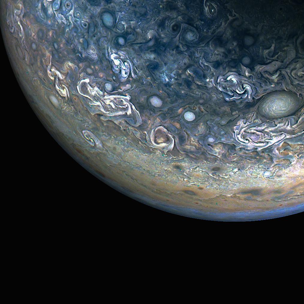
Colorful, Chaotic Jupiter
NASA’s Juno spacecraft captured this color-enhanced view of Jupiter’s northern hemisphere during its 61st close flyby of the giant planet on May 12, 2024.
Citizen scientist Gary Eason made this image using raw data from the JunoCam instrument, applying digital processing techniques to enhance color and clarity. It provides a detailed view of chaotic clouds and cyclonic storms in an area known to scientists as a folded filamentary region. In these regions, the zonal jets that create the familiar banded patterns in Jupiter’s clouds break down, leading to turbulent patterns and cloud structures that rapidly evolve over the course of only a few days.
Learn more about opportunities to do NASA science with citizen science projects.
Image credit: NASA/JPL-Caltech/SwRI/MSSS; Image processing by Gary Eason © CC BY